Map size in jpg-format: 51.039MiB
Click to open in high resolution (open in new tab).
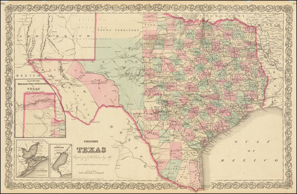
Large format detailed map of Texas, with large insets of the northern panhandle, Galveston and Matagorda Bays and Sabine Lake. The map reflects the relative expansion of the counties of Texas, now plentiful in the east but virtually non-existent in the west. The map shows towns, rivers, mountains, roads, railroads, stations, forts and Indian information.
This was a very interesting time period, as Texas promotion was again in full boom following the Civil War. It was at this time that a band of settlers along the Rio Grande were causing the Mexican Government fits and threatening incursions into Mexico, so much so that Mexican Commission produced an important and very scarce report with maps in their appeal to the US to curb the activities of the Texans.
This example has narrow margins, as issued, which is more or less the norm for Colton's Texas maps during this time period. By 1873, Colton's firm had been surpassed in commercial success by Johnson, SA Mitchell Jr. and O.W. Gray. Colton maps from the 1870s are actually rarer than from the 1850s and 1860s.
Dating the Map
We date the map at 1873, as it pre-dates the creation of Waller County (established in 1873) and pre-dates Aransas County (formed in 1871).
G. W. & C. B. Colton was a prominent family firm of mapmakers who were leaders in the American map trade in the nineteenth century. The business was founded by Joseph Hutchins Colton (1800-1893) who bought copyrights to existing maps and oversaw their production. By the 1850s, their output had expanded to include original maps, guidebooks, atlases, and railroad maps. Joseph was succeeded by his sons, George Woolworth (1827-1901) and Charles B. Colton (1831-1916). The firm was renamed G. W. & C. B. Colton as a result. George is thought responsible for their best-known work, the General Atlas, originally published under that title in 1857. In 1898, the brothers merged their business and the firm became Colton, Ohman, & Co., which operated until 1901, when August R. Ohman took on the business alone and dropped the Colton name.
If you are a student, write to us in telegram: @antiquemaps and indicate what material you need and for what work you need a map in high detail. We are ready to provide material on special terms. For students only!


