Map size in jpg-format: 12.6616MiB
Click to open in high resolution (open in new tab).
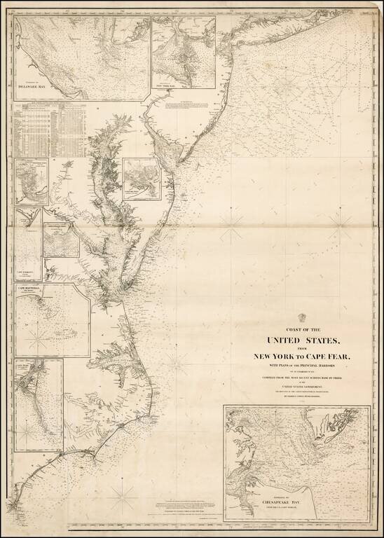
Extremely rare separately issued chart of the eastern part of the United States, from Long Island to Cape Fear, published in New York by Charles Copley.
Includes an extensive table of tides and inset maps showing bays and entrances, including Chesapeake, Cape Fear, New York, Delaware, Hattaras, Ocracoke, Chincotague, and Lookout. Details include lighthouses (shown in red), bays, anchorages, shoals and a host of other fine coastal details.
Copley's chart is extremely rare. We were able to locate only the examples in the British Library.
If you are a student, write to us in telegram: @antiquemaps and indicate what material you need and for what work you need a map in high detail. We are ready to provide material on special terms. For students only!
![[Wall Map] West-Indische Paskaert waer in de graden der breedde over weder zyden vande middelyn wassende so vergrooten dat die geproportioneert syn tegen hunne nevenstaende graden de lengde.](/map/small/60169.jpg)

![[The First Maps in a la poupée Printed Color] Cartes en Couleur des Lieux Sujets aux tremblements de Terre Dans toutes les parties du Monde Selon le Sisteme de l’impulsion Solaire](/map/small/52293op.jpg)