logo

1875. City Water Supply Map of Clear Lake From Surveys made under the direction of the Board of Supervisors of the City of San Francisco by T. R. Scowden, Chief Engineer of City Water Supply . . . 1875

  • City Water Supply Map of Clear Lake From Surveys made under the direction of the Board of Supervisors of the City of San Francisco by T. R. Scowden, Chief Engineer of City Water Supply . . . 1875

City Water Supply Map of Clear Lake From Surveys made under the direction of the Board of Supervisors of the City of San Francisco by T. R. Scowden, Chief Engineer of City Water Supply . . . 1875 information:

Year of creation: 
Resolution size (pixels): 
 11203x4741 px
Disk Size: 
 7.62178MiB
Number of pages: 
 1
Place: 
 San Francisco

Print information. Print size (Width x height in inches):
Printing at 72 dpi 
  155.6 х 65.85
Printing at 150 dpi 
 74.69 х 31.61
Printing at 300 dpi 
 37.34 х 15.8

An example of detailing the file of this map of in a printable high-resolution:

Click to open in high resolution (open in new tab).
Attention! this is just the central piece (central area 960x960 px) of the map file!
This is an example, so that you can see and study the level of detail of a given map. The entire Map will be fully available after payment!

City Water Supply Map of Clear Lake From Surveys made under the direction of the Board of Supervisors of the City of San Francisco by T. R. Scowden, Chief Engineer of City Water Supply . . . 1875

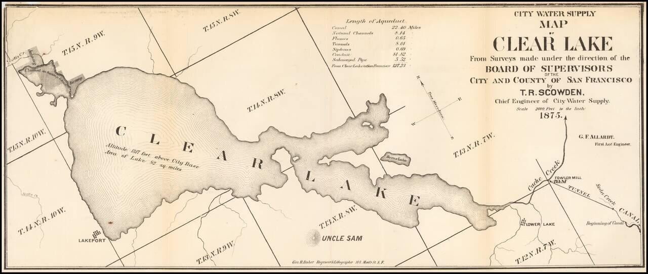
Fine early map of the Clear Lake Area, by George H. Baker, acknowledged as one of early California's leading artists and lithographers whose pioneering work documented California's earliest history.

The map would seem to have been prepared for a pamphlet prepared in or shortly after 1875, utilizing recently prepared information from Whitney and several other maps or the region, as described below.

Our best guess is that this map may in some way relate to the series of water supply maps commissioned by the San Francisco Board of Supervisors in 1875, which were also made by Baker. These includes maps focused on the Spring Valley Reservoir, Clear Lake, Blue Lake Reservoirs, Calaveras Reservoir and a General map of the Surveys of the San Francisco Water Supply, under the direction of T.R. Allardt.


Special conditions for students!

If you are a student, write to us in telegram: @antiquemaps and indicate what material you need and for what work you need a map in high detail. We are ready to provide material on special terms. For students only!

Item information:

Year of creation:
Size:
11203x4741 px
Disk:
7.62178MiB
Number of pages:
1
Place:
San Francisco
Author:
George Holbrook Baker.
$14.99

Related item