Map size in jpg-format: 304.855MiB
Click to open in high resolution (open in new tab).
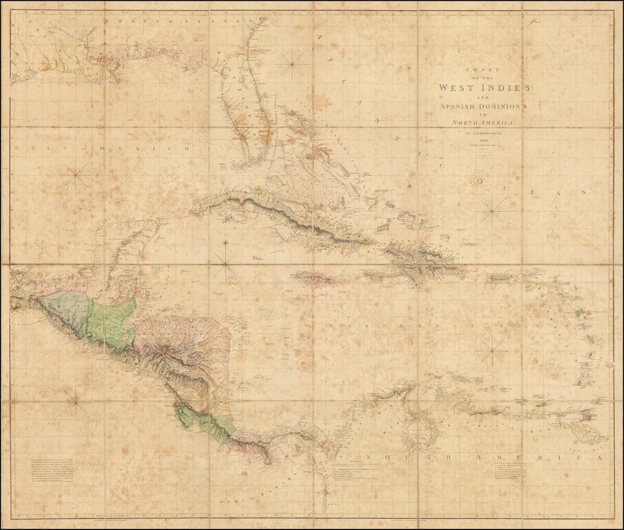
The Best Early 19th-Century Map of Central America and the Caribbean.
Large hand-colored engraved antique map of Florida, the Gulf Coast, West Indies, and Central America, published by Aaron Arrowsmith in London in 1810.
The map contains a detailed treatment of the Gulf Coast and East & West Florida, based in part on the surveys conducted by De Brahm and Romans just prior to the American Revolution. Streeter notes that the coastline follows generally the Carta Esferica of 1799, but with the longitude of Sabine Pass nearly correct, unlike the Carta Esferica. The map presents a highly detailed look at the region on the eve of the War of 1812, at a time when England still had significant colonial interests in the region.
In Central America, the following regions are named: Tabasco, Chiapa, and Yucatan, Mexico; British Honduras (i.e., Belize, unnamed but with original hand-coloring separating the region from Yucatan); "Guatimala" and Vera Paz, parts of the Captaincy General of Guatemala; Honduras; Moskito Shorte; Nicaragua; Costa Rica; Veragua; and Panama.
Interestingly, the map includes a key indicating possible transcontinental canals linking the Atlantic and Pacific Oceans:
Canals proposed to be cut by the Spaniards in 1528.
In the Caribbean, Arrowsmith frequently names "Rochfort" as a source for his information on the islands. This refers to Charles de Rochefort's 1658 book Histoire naturelle et morale des iles Antilles de l'Amerique.
This is the third state of the map, representing the first state of the second edition, in which the copper plate has been cut down, removing the image at the west side The map now goes as far west as Matagorda Bay, Texas, and the Gulf of Tehuantepec.
If you are a student, write to us in telegram: @antiquemaps and indicate what material you need and for what work you need a map in high detail. We are ready to provide material on special terms. For students only!

![[Wall Map] West-Indische Paskaert waer in de graden der breedde over weder zyden vande middelyn wassende so vergrooten dat die geproportioneert syn tegen hunne nevenstaende graden de lengde.](/map/small/60169.jpg)
