logo

1855. Chart Exhibiting The Discoveries of the American Arctic Expedition, In Search of John Franklin With The Revised Survey of theGreenland Coast and the Escape of the Party To the South. Projected by Mr. August Sonntag, From the Original Material. E. K. Kan

  • Chart Exhibiting The Discoveries of the American Arctic Expedition, In Search of John Franklin With The Revised Survey of theGreenland Coast and the Escape of the Party To the South.  Projected by Mr. August Sonntag, From the Original Material.  E. K. Kan

Chart Exhibiting The Discoveries of the American Arctic Expedition, In Search of John Franklin With The Revised Survey of theGreenland Coast and the Escape of the Party To the South. Projected by Mr. August Sonntag, From the Original Material. E. K. Kan information:

Year of creation: 
Resolution size (pixels): 
 4125x6430 px
Disk Size: 
 4.49468MiB
Number of pages: 
 1
Place: 
 New York
Author: 

Print information. Print size (Width x height in inches):
Printing at 72 dpi 
  57.29 х 89.31
Printing at 150 dpi 
 27.5 х 42.87
Printing at 300 dpi 
 13.75 х 21.43

An example of detailing the file of this map of in a printable high-resolution:

Click to open in high resolution (open in new tab).
Attention! this is just the central piece (central area 960x960 px) of the map file!
This is an example, so that you can see and study the level of detail of a given map. The entire Map will be fully available after payment!

Chart Exhibiting The Discoveries of the American Arctic Expedition, In Search of John Franklin With The Revised Survey of theGreenland Coast and the Escape of the Party To the South.  Projected by Mr. August Sonntag, From the Original Material.  E. K. Kan

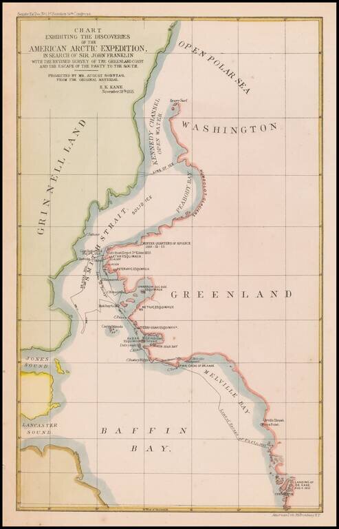
Map of the area of the Upper Part of Baffin Bay and the coasts of Greenland and Grinnell Land, illustrating the tracts of the Second Grinnell Expedition in 1854-1855.

The Second Grinnell expedition of 1853–1855 was an American effort, financed by Henry Grinnell, to determine the fate of the Franklin's lost expedition. Led by Elisha Kent Kane, the team explored areas northwest of Greenland, now called Grinnell Land.

While failing to determine the fate of Sir John Franklin, the expedition set a new record for northward penetration, delineated 960 miles of unexplored coastline north of 82° latitude, and discovered the long-sought open Polar Sea. Kane collected valuable geographical, climate and magnetic observations before abandoning the brig Advance to the pack ice in 1855. While three members of the crew were lost, the epic journey of the survivors inspired the public as a vivid tale of Arctic survival.


Special conditions for students!

If you are a student, write to us in telegram: @antiquemaps and indicate what material you need and for what work you need a map in high detail. We are ready to provide material on special terms. For students only!

Item information:

Year of creation:
Size:
4125x6430 px
Disk:
4.49468MiB
Number of pages:
1
Place:
New York
Author:
Ackerman Litho..
$14.99

Related item