logo

1719. Carte Particuliere Du Perou, Plan De La Ville De Lima .....

  • Carte Particuliere Du Perou, Plan De La Ville De Lima .....

Carte Particuliere Du Perou, Plan De La Ville De Lima ..... information:

Year of creation: 
Resolution size (pixels): 
 9807x12421 px
Disk Size: 
 39.4357MiB
Number of pages: 
 1
Place: 
 Amsterdam
Author: 

Print information. Print size (Width x height in inches):
Printing at 72 dpi 
  136.21 х 172.51
Printing at 150 dpi 
 65.38 х 82.81
Printing at 300 dpi 
 32.69 х 41.4

An example of detailing the file of this map of in a printable high-resolution:

Click to open in high resolution (open in new tab).
Attention! this is just the central piece (central area 960x960 px) of the map file!
This is an example, so that you can see and study the level of detail of a given map. The entire Map will be fully available after payment!

Carte Particuliere Du Perou, Plan De La Ville De Lima .....

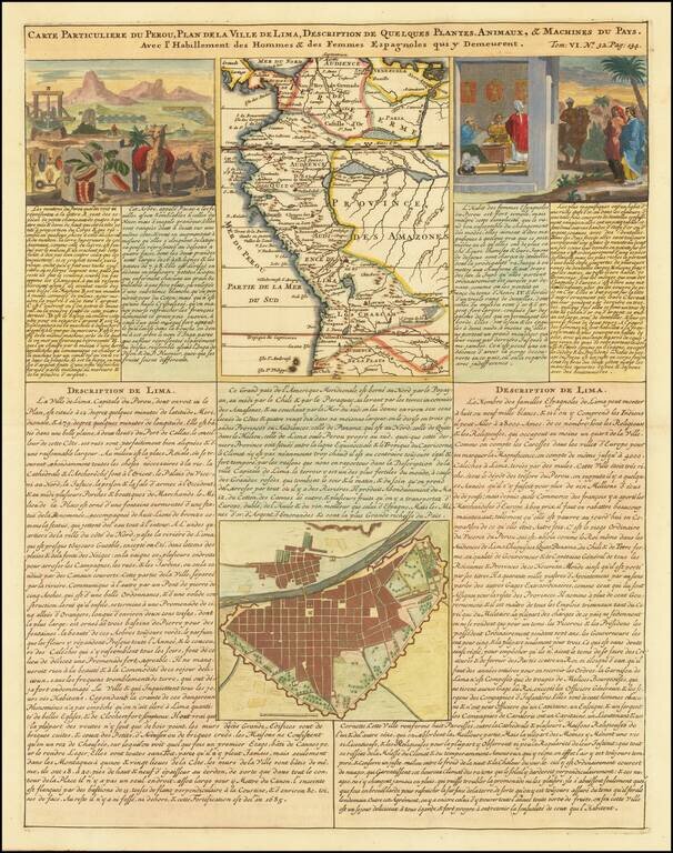
Detailed plan of Lima and regional map of Peru, published in Henri Chatelain's 7 volume Atlas Historique.

The sheet also includes two views showing indigenous flora and fauna and the manner of living of the Spanish women in Peru.

Kershaw 307; Plate 200.

Special conditions for students!

If you are a student, write to us in telegram: @antiquemaps and indicate what material you need and for what work you need a map in high detail. We are ready to provide material on special terms. For students only!

Item information:

Year of creation:
Size:
9807x12421 px
Disk:
39.4357MiB
Number of pages:
1
Place:
Amsterdam
Author:
Henri Chatelain.
$14.99

Related item