Map size in jpg-format: 34.3708MiB
Click to open in high resolution (open in new tab).
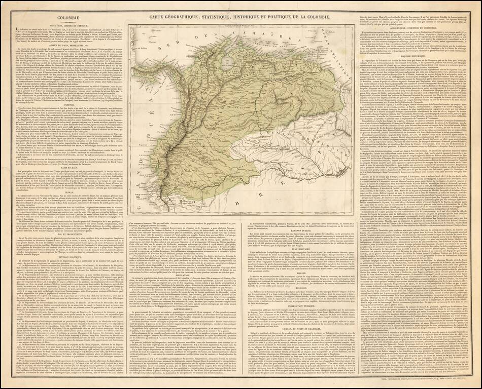
The Rare Precursor -- First Sheet -- For The French Edition of Carey & Lea's American Atlas map of Colombia. "France also seeks to spread the Carey-Lea Atlas . . . This is the first sheet of what has appeared."
Rare separately published map of Colombia, designed and engraved by J. M. Darmet and pubilshed by Imprimerie de Cosson in Paris.
This fine map of Colombia, published shortly after its independence, was apparently the first separately published sheet of what would ultimately become Buchon's Atlas Gégraphique Statistique, historique et chronologique des deux Ameriques et des isles adjacentes; traduit de l'atlas exécuté en Amerique d'aprés Lesage, avec des nombreuses corrections et augmentations, published in Paris in 1825.
Curiously, the map bears no real similarity to the map ultimately published by Buchon, other than the format of the text. The publisher, engraver and all other aspects of the work were apparently redone by the time Buchon's Atlas was published: https://www.raremaps.com/gallery/detail/42616/carte-geographique-statistique-et-historique-de-l-buchon
The map was announced on page 249 of volume 17 of the Neue allgemeine geographische und statistische Ephemeriden (1825) as follows:
Auch in Frankreich sucht man den Carey-Leaschen Atlas zu verbreiten, und hatte denselben mit dem Versprechen, den Text dem neuern Zustande, der Dinge gemäss anzupassen, schon vor einiger Zeit angekündigt. Diess ist das erste Blatt, was davon erschienen ist.
Bei der Charte liegt offenbar die Carey'sche zum Grunde, indess hat der Herausgeber nicht die generelle Eintheilung Carey's in Cundinamarca, Quito und Spanish Guayana adoptirt, sondern aus la Rochette, die sämmtlichen veralteten Provinzialnamen hervorgesucht. Das Dutch Guyana Carey's hat er zwar in Guiana anglaise verwandelt, aber für Rio Norte höchst unrichtig Guiana portugaise gesetzt. Uebrigens hat die Charte ein gefälliges Aeussere,
Was den Text betrifft, so hat der Herausgeber Wort gehalten und denselben bis auf die jetzige Zeit fortgeführt. Unter der Rubrik Gouvernement, welche bei Carey ganz fehlt, ist ein Abriss der Staatsverfassung dieses Freistaat gegeben. Die unnütze Rubrik Canaletc. ist weggelassen, dagegen neu revenus publies, tat militair- und marine.
Translation:
France also seeks to spread the Carey & Lea Atlas, and has promised to adapt the text to the new state of affairs, according to certain things, some time ago. This is the first sheet of what has appeared.
In the chart the Carey's seem to be the basis, but the editor did not adopt the general division of Carey in Cundinamarca, Quito, and Spanish Guiana, but out of la Rochette, all the outdated provincial names. The Dutch Guyana Carey's he has indeed turned into British Guiana, but set for Rio Norte very wrong Portuguese Guiana. By the way, the charter has a pleasing appearance.
As far as the text is concerned, the editor has kept his word and continued it to the present time. Under the heading Gouvernement, which is missing at Carey, is section on the new Colombian Constitution. The useless rubric Canal etc. is omitted, on the other hand public revenue, military and marine.
Rarity
The map is extremely rare. We locate only one copy of the map at Bibliotheque National de France (dated 1824). There is also a later variant edition of the map at the Bibliotheque National de France (dated "apres 1824"), with and added scale of miles and 8 columns of text (rather than 4). The Paris Natural History Museum also lists a copy, as does the British Library (erroneously dated 1840).
If you are a student, write to us in telegram: @antiquemaps and indicate what material you need and for what work you need a map in high detail. We are ready to provide material on special terms. For students only!