Map size in jpg-format: 23.9119MiB
Click to open in high resolution (open in new tab).
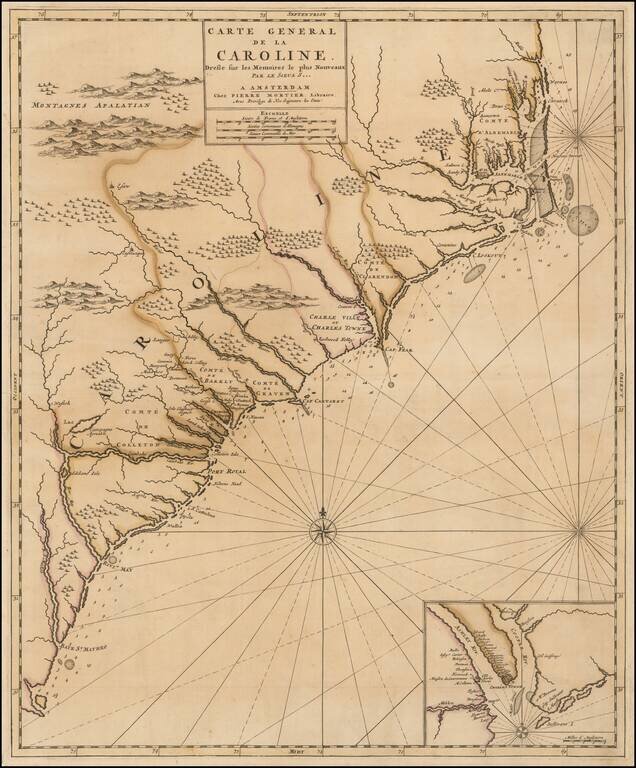
French Edition of An Important Early Map of the Carolinas
First state of Mortier's map of the Carolinas, one of the most detailed and up to date maps of the period.
Mortier's map is based upon Thornton, Morden & Lea's virtually unobtainable map of the region, first published in 1685. Cumming observed that the two maps are identical to the smallest geographical detail and provides the most complete and up to date view of the Carolinas available at the end of the 17th century. The original counties are named, and numerous estates and plantations are identified.
The map includes an inset of Charleston, founded in 1669.
Mortier's map is of the earliest obtainable maps of the region to reflect any significant settlement. Extends from Albermarle County to south of the Savannah River. Curiously, there is also a large "Charles Ville ou Charles Town" shown next to Cape Fear, a reference to a short-lived settlement established a few years prior to Charleston and abandoned a few years later. Please see http://www.carolana.com/NC/Towns/Charles_Town_NC.html for a more detailed history.
Carolina was established in 1663 when Charles II granted the province to eight favorites, known as the Lord Proprietors, who had helped him regain the throne of England. The original grant included the territory between the 31st degree to 36 1/2 degrees north latitude, from Jekyll Island, Georgia, to Currituck Inlet, North Carolina. Two years later, the tract was enlarged to include the land between the 29th and the 31st degree north latitude, thus adding a large portion of Florida. The grant extended west to the Pacific Ocean ( Degrees of Latitude, p.93).
Carolina was divided into two separate colonies in 1712, and South Carolina received its royal charter in 1729.
States
First state: Pierre Mortier imprint.
Second state: Pierre Mortier imprint with plate number in lower right.
Third state: Covens & Mortier imprint with plate number in lower right.
If you are a student, write to us in telegram: @antiquemaps and indicate what material you need and for what work you need a map in high detail. We are ready to provide material on special terms. For students only!


![[The First Maps in a la poupée Printed Color] Cartes en Couleur des Lieux Sujets aux tremblements de Terre Dans toutes les parties du Monde Selon le Sisteme de l’impulsion Solaire](/map/small/52293op.jpg)