logo

1719. Carte Du Gouvernement Militaire D'Angleterre Ou L'On Represente L'Etat Des Officiers De Guerre Et Celui Des Forces De Terre Et De Mer

  • Carte Du Gouvernement Militaire D'Angleterre Ou L'On Represente L'Etat Des Officiers De Guerre Et Celui Des Forces De Terre Et De Mer

Carte Du Gouvernement Militaire D'Angleterre Ou L'On Represente L'Etat Des Officiers De Guerre Et Celui Des Forces De Terre Et De Mer information:

Year of creation: 
Resolution size (pixels): 
 3853x2961 px
Disk Size: 
 2.78513MiB
Number of pages: 
 1
Place: 
 Paris
Author: 

Print information. Print size (Width x height in inches):
Printing at 72 dpi 
  53.51 х 41.13
Printing at 150 dpi 
 25.69 х 19.74
Printing at 300 dpi 
 12.84 х 9.87

An example of detailing the file of this map of in a printable high-resolution:

Click to open in high resolution (open in new tab).
Attention! this is just the central piece (central area 960x960 px) of the map file!
This is an example, so that you can see and study the level of detail of a given map. The entire Map will be fully available after payment!

Carte Du Gouvernement Militaire D'Angleterre Ou L'On Represente L'Etat Des Officiers De Guerre Et Celui Des Forces De Terre Et De Mer

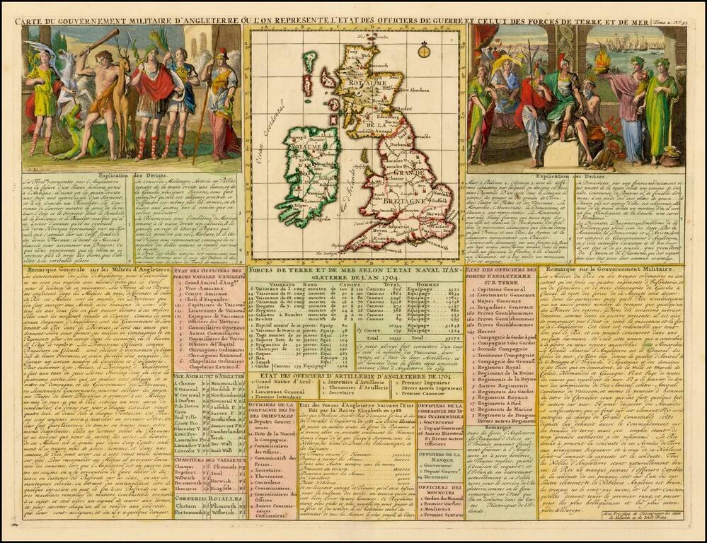
Decorative map of the British Isles with idyllic scenes showing councils of the various military officers of the British Isles.

From Chatelain's monumental Atlas Historique.

Henri Abraham Chatelain (1684-1743) was a Huguenot pastor of Parisian origins. Chatelain proved a successful businessman, creating lucrative networks in London, The Hague, and then Amsterdam. He is most well known for the Atlas Historique, published in seven volumes between 1705 and 1720. This encyclopedic work was devoted to the history and genealogy of the continents, discussing such topics as geography, cosmography, topography, heraldry, and ethnography. Published thanks to a partnership between Henri, his father, Zacharie, and his younger brother, also Zacharie, the text was contributed to by Nicolas Gueudeville, a French geographer. The maps were by Henri, largely after the work of Guillaume Delisle, and they offered the general reader a window into the emerging world of the eighteenth century.


Special conditions for students!

If you are a student, write to us in telegram: @antiquemaps and indicate what material you need and for what work you need a map in high detail. We are ready to provide material on special terms. For students only!

Item information:

Year of creation:
Size:
3853x2961 px
Disk:
2.78513MiB
Number of pages:
1
Place:
Paris
Author:
Henri Chatelain.
$14.99

Related item