Map size in jpg-format: 5.40897MiB
Click to open in high resolution (open in new tab).

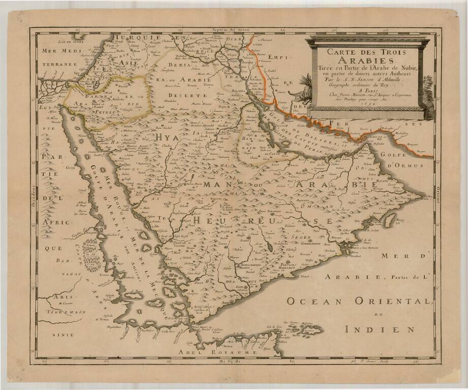
Rare Map of the Arabian Peninsula by Sanson
An excellent example of this scarce map of the Arabian Peninsula, referencing the "Trois Arabies" (Three Arabias).
This exemplary work by the father of French cartography, Nicolas Sanson, is one of the few examples of seventeenth-century European cartography of the region. At this time, France was experiencing increased trade and involvement with the Arabian Peninsula through the burgeoning French silk trade. Additionally, overall European economic interest in the region was growing.
The map extends from the Red Sea and African coast to the edge of the Persian Empire. Cities are depicted with settlement illustrations according to their size, while towns are simple dots. The relative accuracy of Sanson’s work is rare for a time when Europe knew very little of the Arabian Peninsula and its cities. However, the Peninsula’s interior is criss-crossed with spurious mountain ranges.
At top right, the sober monument-style map cartouche covers inland Persia and includes the title, authorship, printing privilege, and the 1654 publication date. The subtitle reads: “tirée en partie de l'Arabe de Nubie, en partie de divers autres Autheurs” (taken in part from the Arab of Nubia, in part from various other authors).
The “Arab of Nubia” refers to twelfth-century Moroccan Arab geographer al-Idrisi. Al-Idrisi’s work Kitab nuzhat al-mushtaq fi'khtiraq al-afaq, also known popularly as the Tabula Rogeriana, is an exhaustive description and accompanying map of the world commissioned by King Roger II of Sicily. A Latin translation of Al-Idrisi’s work was published in 1619 as Geographia Nubiensis, from which Sanson derived the information to populate this map.
The Three Arabias on this map refer to regions named during the Hellenistic period, popularized by Ptolemy: Arabia Petrae (Petree), Arabia Deserta (Desertee), and Arabia Felix (Heureuse). Arabia Petrae (Stony Arabia), Rome’s province, was named for its capital, Petra. Arabia Deserta signifies the desert interior of the peninsula, and Arabia Felix (Fortunate Arabia) was named for its relative greenery and fortunate agricultural climate. The bounds of these three regions often differ between mapmakers and across time, although the names stay consistent.
The naming of water bodies on this map evidences contrasting names given by various sources. The Gulf between Persia and Saudi Arabia is called the "Golfe de Balsera, et Mer Del Cattif, autrefois Golfe de Perse" (Balsera Gulf and Sea of Cattif formerly known as the Gulf of Persia). Balsera (Basra, Iraq) and Cattif (Qatif, Saudi Arabia) are both longstanding ports on the Persian Gulf. Ptolemy and his contemporaries named this body of water the Persian Gulf, hence the name as used here.
Between Africa and the Arabian Peninsula, the sea is labeled “Mer Rouge et Mer de la Mecque, Golfe D’Arabie aux Anciens” (Red Sea and Sea of Mecca, Arabian Gulf to the ancients). The Red Sea was referred to by the Ottomans as the Sea of Mecca, so Sanson likely worked from authors with Turkish sources. Alternate spellings are provided for the Bab-el-Mandeb (lit. “Gate of Tears”), the treacherous narrow strait separating Yemen and the Horn of Africa.
Iraq (Yerak) and Bahrain (Bahraim) are separately demarcated areas, and Arabie Heureuse is also labeled as Yemen (Hyaman). Ottoman control of the Holy Land is clearly marked.
This map is quite scarce on the market and is highly sought-after by collectors of the Arabian Peninsula and the Middle East.
If you are a student, write to us in telegram: @antiquemaps and indicate what material you need and for what work you need a map in high detail. We are ready to provide material on special terms. For students only!

![[Europe, Mediterranean, Asia Minor and the Persian Empire]](/map/small/43558.jpg)
