logo

1740. Carte Des Isles De Maiorque Minorque et D'Yvice . . .

  • Carte Des Isles De Maiorque Minorque et D'Yvice . . .

Carte Des Isles De Maiorque Minorque et D'Yvice . . . information:

Year of creation: 
Resolution size (pixels): 
 14018x12048 px
Disk Size: 
 44.1455MiB
Number of pages: 
 1
Place: 
 Augsburg
Author: 

Print information. Print size (Width x height in inches):
Printing at 72 dpi 
  194.69 х 167.33
Printing at 150 dpi 
 93.45 х 80.32
Printing at 300 dpi 
 46.73 х 40.16

An example of detailing the file of this map of in a printable high-resolution:

Click to open in high resolution (open in new tab).
Attention! this is just the central piece (central area 960x960 px) of the map file!
This is an example, so that you can see and study the level of detail of a given map. The entire Map will be fully available after payment!

Carte Des Isles De Maiorque Minorque et D'Yvice . . .

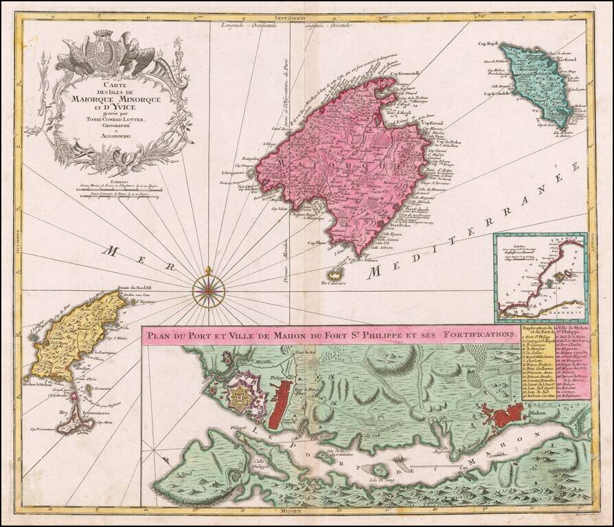
Striking map of the Balearic Islands, with a large plans of the Harbor and Town of Mahon.

The map includes a striking coat of arms and windrose.

Tobias Conrad Lotter (1717-1777) is one of the best-known German mapmakers of the eighteenth century. He engraved many of the maps published by Matthaus Seutter, to whose daughter Lotter was married. He took over Seutter’s business in 1756. Lotter’s son, M. A. Lotter, succeeded his father in the business.


Special conditions for students!

If you are a student, write to us in telegram: @antiquemaps and indicate what material you need and for what work you need a map in high detail. We are ready to provide material on special terms. For students only!

Item information:

Year of creation:
Size:
14018x12048 px
Disk:
44.1455MiB
Number of pages:
1
Place:
Augsburg
Author:
Tobias Conrad Lotter.
$14.99

Related item