Map size in jpg-format: 6.31492MiB
Click to open in high resolution (open in new tab).
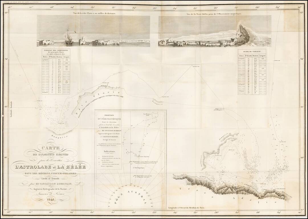
Reporting the Correct Location of the Southern Magnetic Pole -- Among the Very First Maps to Report Sighting of the Antarctic Landmass.
Large engraved folding map of the Antarctic coast south of Van Diemen's Land.
The map documents the leg of the second voyage of the Astrolabe during which Dumont-Durville attempted to reach the Southern Magnetic Pole at the behest of King Louis-Phillipe. Dumont-Durville had been instructed to claim the pole for France, and failing that Dumont's expedition was asked to equal the most southerly latitude of 74°34'S achieved in 1823 by James Weddell.
The map includes an inset chart on a larger scale, showing the track south from Van Diemen's Land and correctly locating the Southern Magnetic Pole. It is titled: "Position du Pole Magnetique D'apres les observations faites a bord des Corvettes l'Astrolabe et la Zelee par Mm. Vincendon-Dumoulin Ingenieur Hydrographe de la Marine..."
Durville was among the first people to sight the Antarctic landmass which Cook had hypothesized was unreachable when he was continually foiled by ice on his Third Voyage.
The map comes from volume eight (1845) of Dumont-Durville's Voyage au pole sud et dans l'Océanie sur les corvettes l'Astrolabe et la Zélée.
Jules Sébastien César Dumont d'Urville (23 May 1790 - 8 May 1842) was a French explorer, naval officer and rear admiral, who explored the south and western Pacific, Australia, New Zealand and Antarctica. As a botanist and cartographer, he left his mark by giving his name to several seaweeds, plants and shrubs, and places such as D'Urville Island.
If you are a student, write to us in telegram: @antiquemaps and indicate what material you need and for what work you need a map in high detail. We are ready to provide material on special terms. For students only!
![[Eastern Hemisphere Globe Gores] (Nova et integra universi Orbis descriptio)](/map/small/54480.jpg)

