Map size in jpg-format: 21.2622MiB
Click to open in high resolution (open in new tab).
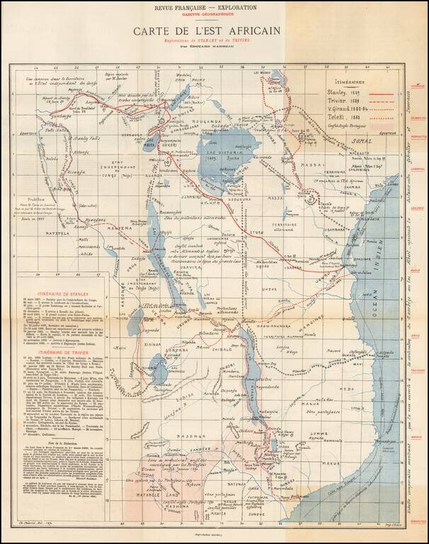
Rare map of East Africa, published by the Gazette Geographique in Paris.
The map details the routes of 4 explorers in East Africa, along with the area in conflict between the English and the Portuguese. The explorer routes shown include:
The details of the expeditions or Henry Morton Stanley and Emile Trivier are shown on the map. Below is information on the other two explorers.
Giraud
In 1882-1884 the French naval lieutenant Victor Giraud proceeded by the north of Nyasa to Lake Bangweulu, of which he made the first fairly correct map.
Teleki
Count Sámuel Teleki de Szék (November 1, 1845 – March 10, 1916) was a Hungarian explorer who led the first expedition to Northern Kenya. He was the first European to see, and name, Lake Rudolf (Lake Turkana), though the existence of the lake was known in Europe long before Teleki arrived at the scene.
The map accompanied a report published in Revue francaise de l'etranger et des colonies et Exploration, gazette, Volume 11, which included and article covering the Voyage of Captain Trivier to Equatorial Africa, Congo and Mozambique, based upon correspondence from Kassongo dated April 1889 and Mozambique dated December 1889.
If you are a student, write to us in telegram: @antiquemaps and indicate what material you need and for what work you need a map in high detail. We are ready to provide material on special terms. For students only!


