logo

1807. Carte De La Partie Sud-Est De La Nouvelle Guinee Reconnue Par le Contre-Amiral Bruny-Dentrecasteaux en Jin 1793 . . .

  • Carte De La Partie Sud-Est De La Nouvelle Guinee Reconnue Par le Contre-Amiral Bruny-Dentrecasteaux en Jin 1793 . . .

Carte De La Partie Sud-Est De La Nouvelle Guinee Reconnue Par le Contre-Amiral Bruny-Dentrecasteaux en Jin 1793 . . . information:

Year of creation: 
Resolution size (pixels): 
 19163x13002 px
Disk Size: 
 22.5123MiB
Number of pages: 
 1
Place: 
 Paris

Print information. Print size (Width x height in inches):
Printing at 72 dpi 
  266.15 х 180.58
Printing at 150 dpi 
 127.75 х 86.68
Printing at 300 dpi 
 63.88 х 43.34

An example of detailing the file of this map of in a printable high-resolution:

Click to open in high resolution (open in new tab).
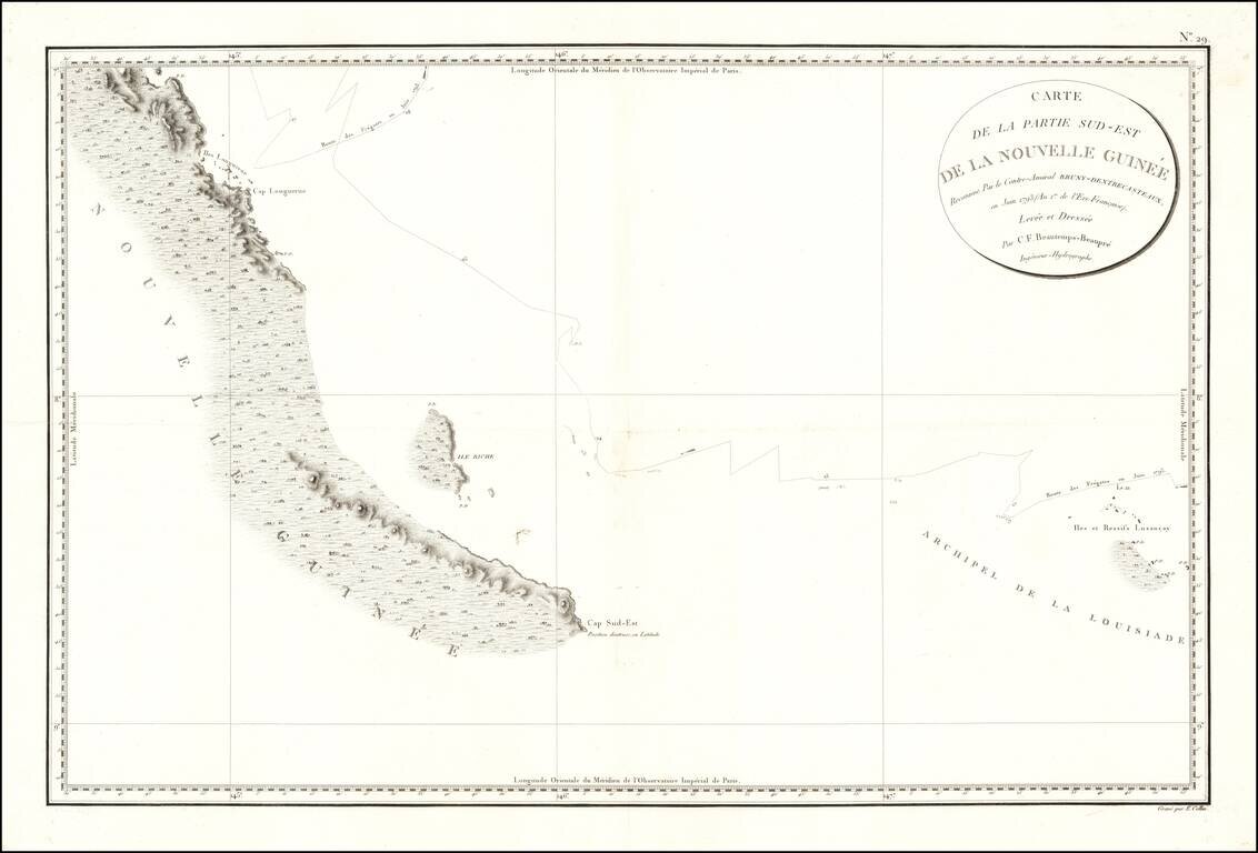
Attention! this is just the central piece (central area 960x960 px) of the map file!
This is an example, so that you can see and study the level of detail of a given map. The entire Map will be fully available after payment!

Carte De La Partie Sud-Est De La Nouvelle Guinee Reconnue Par le Contre-Amiral Bruny-Dentrecasteaux en Jin 1793 . . .

Papua New Guinea

The chart appeared in Atlas du voyage de Bruny-Dentrecasteaux, contre-amiral de France, commandant les fregates la Recherche et l'Esperance, fait par ordre du gouvernement en 1791, 1792 et 1793 : publie par ordre de sa majeste l'empereur et roi, sous le ministere de son excellence le vice-amiral Decres ...

Finally engraved sea chart of a part of Papua New Guinea that Antoine Bruni d'Entrecasteaux traveled on his search for La Perouse in 1792 and 1793.

This chart follows Bruni d'Entrecasteaux's track from the Louisiade Archipelago (named for Louis XV by Louis Antoine de Bougainville) up the southeastern coastline of Papua New Guinea in June 1793, just a month before the explorer died of scurvy. After his death, the expedition ended in the East Indies amid open clashes between the Royalists and the Republicans in the crew. Condition:


Special conditions for students!

If you are a student, write to us in telegram: @antiquemaps and indicate what material you need and for what work you need a map in high detail. We are ready to provide material on special terms. For students only!

Item information:

Year of creation:
Size:
19163x13002 px
Disk:
22.5123MiB
Number of pages:
1
Place:
Paris
Author:
Antoine Brun D'Entrecasteaux.
$14.99

Related item