Map size in jpg-format: 6524160B
Click to open in high resolution (open in new tab).
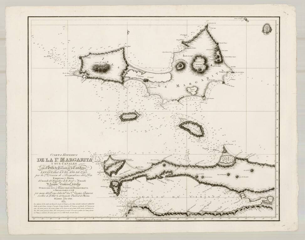
Fine map of Margarita Island and the Gulf of Cariaco, as surveyed by the Spanish at the end of the 17th Century.
The present chart represents the southeastern most expeditionary work of Brigadier Joaquin Franciso Fidalgo, at the end of the 18th Century.
The chart is drawn from the hydrographical expeditions of Churruca and Fidalgo. Joaquin Francisco Fidalgo was an important Spanish Naval Officer and Hydrographer. Fidalgo was promoted to commander in 1791, and from 1792 captained one of two divisions of brigs, along with Cosme Damian Churruca, which charted the coast of North America in order to create the first Spanish hydrographical atlas of the coastlines of North America, designed to promote and improved Spanish trade and commerce with the Gulf of Mexico, Florida, Mainland and the Antilles. After 1794, Fidalgo continued his work between Panama and Guajira, Venezuala.
Fidalgo later co-founded a nautical school in Cartagena de Indias . Fidalgo returned to Spain in 1810, at which time he became the commander of the Hydrographic Office.
The map is dedicated to the memory of Don Jose de Espinosa Tello de Portugal, one of Spain's great late 18th and early 19th Century explorers during the age of Spanish Enlightenment.
The present example has the "Nota" below the title. In subsequent issues, the Nota is moved to the bottom left and an additional "F ... indica fanal" is added at the end of the Nota.
The Dirección de Hidrografía, or the Directorate of Hydrographic Works, was established in 1797. Its roots were in the Casa de Contratación, founded in 1503 in Sevilla, which housed all the charts of the Spanish Empire and oversaw the creation and maintenance of the padrón real, the official master chart. The Casa, now in Cadiz, was shuttered in 1790, but Spain still needed a hydrographic body. In response, the Dirección was created in 1797. One of its first projects was the publication of charts from the Malaspina Expedition (1789-1794). The Dirección oversaw not only publication, but also surveying. The Dirección was abolished in the early twentieth century, when their work was distributed to other organizations.
If you are a student, write to us in telegram: @antiquemaps and indicate what material you need and for what work you need a map in high detail. We are ready to provide material on special terms. For students only!


![[Signed Political Satire Artwork] Vietnam ... Vietnam ... Vietnam ...](/map/small/68726.jpg)