Map size in jpg-format: 620699B
The Only Known Example of Blanchard's Pocket Map of California & Nevada
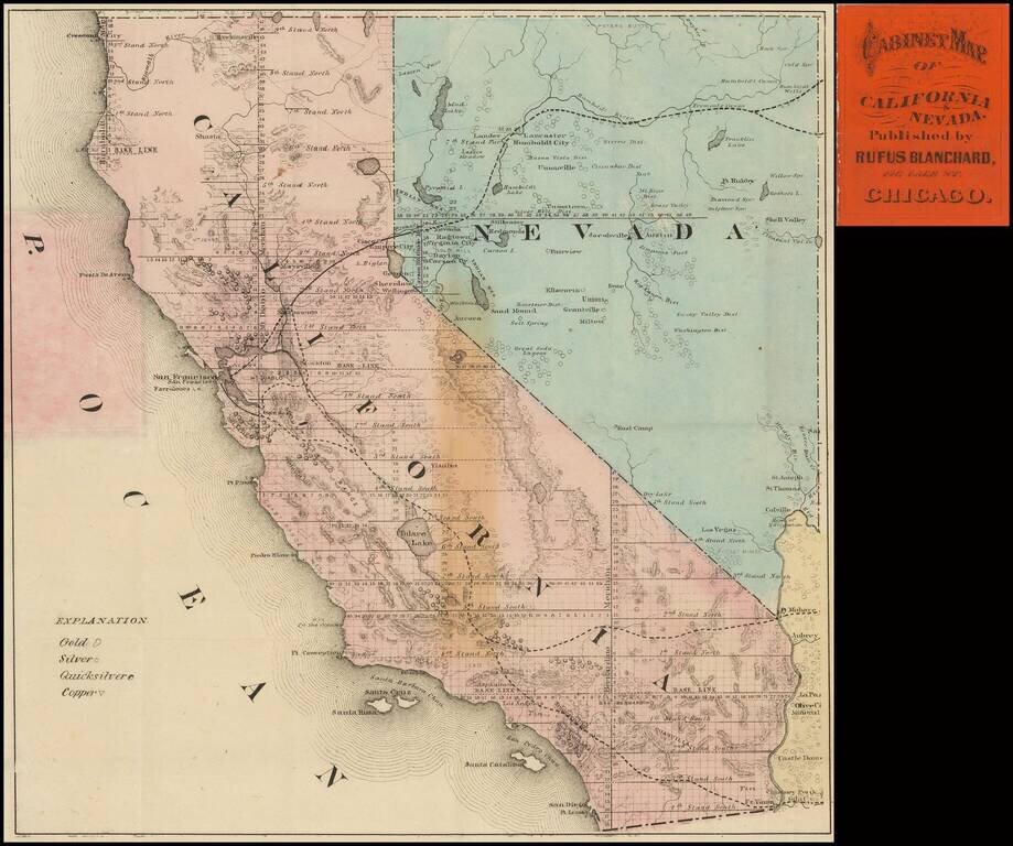
Rare Pocket Map of California and Nevada, published in Chicago by Rufus Blanchard.
Interesting pocket map of California and Nevada, published during boom times in Nevada, and ongoing development in California financed in large part by the mineral wealth of Nevada. A small strip of Arizona is also shwon, filled with mining regions.
The few rail lines are shown, and those proposed, the connection to the East not quite accomplished. A note on the Colorado River notes the "Head of Navigation" near Colville, just west of the Grand Canyon.
Lake Tahoe is called Lake Bigler and the Potosi mines south of Las Vegas are also shown.
Fort Ruby (also known as Camp Ruby) is shown--a fort which opearted only from 1862 to 1869, for the purpose of protecting the Pony Express Route during the American Civil War.
Virginia City, Gold Hill, Ragtwn, Dayton, Empire City, Genoa, Sheridan, Wellington and Carson City are all located in Comstrock region, but many other Nevada mining districts area also noted, including:
This map focuses on the locations of various mineral resources and the land that has been surveyed by the General Land Office.
Includes an advertisement for Blanchard's Cabinet Map of the United States on inside of front cover.
The map is of the utmost rarity. OCLC locates no other surviving examples of the map.
Provenance: Warren Hecktrotte Colletion, PBA Galleries, December 2015; Ken Harrison, February 1995.
If you are a student, write to us in telegram: @antiquemaps and indicate what material you need and for what work you need a map in high detail. We are ready to provide material on special terms. For students only!

![Mexique par Th. Duvotenay…1843 [Republic of Texas]](/map/small/67925.jpg)
