Map size in jpg-format: 136.978MiB
Click to open in high resolution (open in new tab).

Published in Calcutta
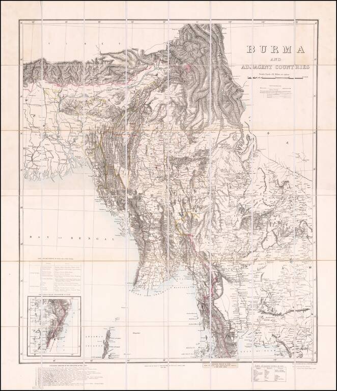
Finely executed map of Burma, compiled by Colonel Henry Ravenshaw Thullier and published by the Survey of India Office.
One of the most accurate maps of Burma for of the period, derived from a host of contemporary sources identified at the bottom left, a total of 14 maps published by the Survey of India, Royal Geographical Society, and various other primary sources.
The map is the first complete, broadly accurate map of Burma, drawn from the most recent British military surveys, bringing together for the first time all the various regional surveys in the wake of Britain’s conquest of the entire country during the Third Anglo-Burmese War (November 14-27, 1885).
The map was made by the Survey of India (Burma had been annexed to British India) under the direction of Colonel Henry Ravenshaw Thuillier, the Surveyor General of India, and was printed at their headquarters in Calcutta in March 1890. The map embraces all of Burma, plus Assam, parts of Bengal (including the Calcutta area), various Indian border states, plus part of Siam (Thailand) and Tibet. It shows both Lower and Upper Burma with great detail and accuracy to a scale of 32 miles to 1 inch, the result of scientific British surveys. All coastlines and rivers are carefully delineated, while mountains ranges are shown by hachures, with spot heights in feet. Most prominent is the mighty Irrawaddy River, the lifeline of the nation. Every significant city and town is marked, while all of Burma’s districts are named and outlined in orange
A table at the lower right identifies place names in English, Burmese and Siamese. The map was advertised for sale uncolored (Three Rupees) or colored (Three Rupees Eight Annas).
If you are a student, write to us in telegram: @antiquemaps and indicate what material you need and for what work you need a map in high detail. We are ready to provide material on special terms. For students only!

![Il Disegno Della Terza Parte Dell' Asia [Gastaldi's Wall Map of SE Asia with extra panels!]](/map/small/30554hbp.jpg)
