Map size in jpg-format: 42.7246MiB
Click to open in high resolution (open in new tab).
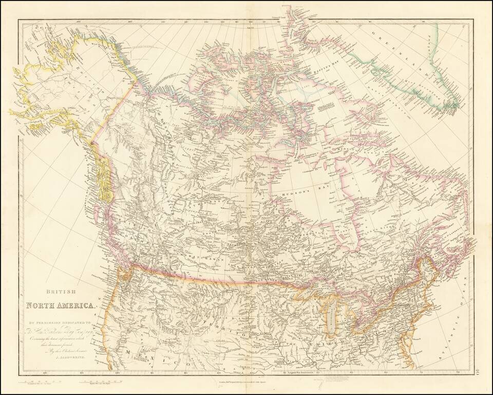
Detailed Map of British Possessions in North America—Rare Late Edition!
Highly-detailed state of John Arrowsmith’s map of British possessions in North America, published in multiple editions between 1832 and 1859. This is a late edition, from the final year the map was used, 1859.
The map shows all of present-day Canada, as well as Greenland, Alaska (shown as “Russian America”), and the northern United States. This is one of the best maps of the period in its depiction of Western and Upper Canada, an advantage that resulted from the Arrowsmiths’ close relationship with the Hudson’s Bay Company.
Oddly for an otherwise highly-updated map, present-day Northern California and parts of Nevada, Arizona, and Utah are still shown as Mexican territory, with the northern boundary indicated as having been agreed upon in 1819. This refers to the Transcontinental, or Adams–Onís Treaty of 1819, which compelled Spain to cede Florida and give up its claim to Oregon Country in exchange for sovereignty over Texas. However, this boundary was superseded by Treaty of Guadalupe-Hidalgo, which forced Mexico to give up what is today Texas, California, New Mexico and Arizona.
The map contains many place names and notes about voyages and discoveries. Many indigenous groups are noted in italic font. Rivers both large and small are depicted, and relief is shown by hachures.
The area around and to the north of the Arctic Circle have exceptional detail for the time. For example, as compared to previous states, this one has a nearly complete islandscape north of Hudson Bay. Details of this region were filled in by voyages that were searching for John Franklin’s lost expedition of 1845. Alaska also has considerably more information included as compared to previous states.
The map was published in Arrowsmith’s London Atlas of Universal Geography, multiple editions of which were printed between 1832 and 1859.
Arrowsmith and the Hudson’s Bay Company
As evidenced by the dedication in the bottom left corner, this map is heavily influenced by the Hudson’s Bay Company. Like his uncle, mapmaker Aaron Arrowsmith, John Arrowsmith enjoyed a strong working relationship with the Hudson’s Bay Company, which allowed both men unfettered access to its files in exchange for the production of a series of maps every several years recording the latest topographical information. It was in this capacity as the unofficial cartographers of the HBC that the Arrowsmith family firm became known for producing maps depicting the latest information on the northern part of North America.
The Hudson’s Bay Company is considered the oldest incorporated joint-stock merchandising company in the English-speaking world, still active today in real estate, merchandising, and natural resources. The HBC was incorporated in England in 1670 to seek a Northwest Passage to the Pacific and to occupy lands adjacent to the Hudson Bay, conducting commercial activities on these lands. The territories originally granted to the HBC were named Rupert’s Land, the boundaries of which were never clearly defined but understood to extend from Labrador to the Rocky Mountains, and from the headwaters of the Red River to the Chesterfield Inlet on the Hudson Bay.
The HBC was dominant in the fur trade, but after the British conquest of Canada in 1759–60, the company faced increasing competition. By 1783, competitors to the HBC had formed the North West Company, and the two clashed for the next several decades. After armed clashes in the early nineteenth century, the British government in 1821 united the two companies under the name and charter of the Hudson’s Bay Company, which was given exclusive license to trade in Rupert’s Land, in the Northwest Territories beyond Rupert’s Land, and on the Pacific Slope. This and subsequent agreements effectively granted the HBC an almost unbroken monopoly for the next century.
One vestige of the HBC on this map is Fort Astoria, where the Columbia River enters the Pacific Ocean. Fort Astoria, also known as Fort George, was built by the Pacific Fur Company (PFC), which was financed by John Jacob Astor. On this state of the map, both names are included, whereas early states only had Fort Astoria to mark the place. The fort was the first American-built settlement on the Pacific Coast. However, the PFC folded as a result of the War of 1812. It was bought by the Montreal-based North West Company (NWC), which was in turn absorbed by the larger HBC. The HBC closed Fort George in 1825 in favor of Fort Vancouver, which is also marked on this map. However, with the arrival of increasing numbers of American merchants on the Columbia, the HBC decided to reopen Fort George.
Hudson’s Bay Company and the Oregon Question
The presence of Fort Astoria references the decades-long dispute between Britain and the United States over Oregon Country, as it was one of the many settlements brought up in negotiations. Although not marked as such on the map, Oregon Country lies to the north of the 1819 boundary line between Mexico and the United States and is bounded in the east by the Rocky Mountains and in the north by the 49th parallel (which is shown here). The area corresponds to present-day Oregon, Washington, Idaho, parts of Montana and Wyoming, and part of British Columbia.
This dispute began shortly after the conclusion of the War of 1812. Britain and the U.S. advanced competing claims for control of Oregon Country, with the former citing George Vancouver’s exploration of the northwest coast and the latter citing Robert Gray’s discovery of the Columbia River. At the London Convention of 1818, diplomats from the two countries agreed to joint occupation of the territory for the next ten years. In 1825, the two countries resumed negotiations in London, but, unable to come to an agreement, the joint occupation treaty was renewed for an indefinite term.
After this agreement, Britain expanded its commercial interests in Oregon Country through the fur-trading activities of the Hudson’s Bay Company, starting around 1821. At the same time, starting in 1834, when this state of the map was published, American migration to Oregon Country increased, continuing into the 1840s. By 1842, the HBC’s influence had declined, partly due to the opening of Chinese ports to British commerce, which shifted Britain’s focus in the Pacific. However, it continued to control the British part of Oregon Country until 1858.
With increasing American migration to Oregon Country, these migrants argued for protection and the extension of American laws to the territory. Petitions to Congress to secure American rights in Oregon contained criticisms of the HBC, leading to anti-British sentiments among settlers. New negotiations between Britain and the U.S. in 1842 led to the Webster-Ashburton Treaty, which reaffirmed the 49th parallel as the border between the U.S. and Canada as far west as the Rocky Mountains, but this still did not fully resolve the dispute.
The boundary dispute over Oregon Country gained prominence in the U.S. presidential campaign of 1844, with the winner, James K. Polk, embracing expansion. By 1845, the famous “54-40 or Fight” rallying cry, referring to the southern boundary of present-day Alaska, became popular among expansionists. Finally, negotiations in 1846 led to the Oregon Treaty, which extended the international boundary at the 49th parallel all the way into the Puget Sound, leaving Vancouver Island to the British.
Russian America
On the present map, present-day Alaska is called “Russian America,” indicating Russia’s control of the territory during this time. Russian exploration of Alaska began with the First and Second Kamchatka Expeditions in 1724–1730 and 1732–1743, led by Vitus Bering (for whom the Bering Strait is named). By 1743, Russian hunters of fur-bearing animals joined companies organized by Siberian merchants and voyaged from Kamchatka and Okhotsk to acquire sea otters, whose fur was traded with China.
In 1784, merchant Grigory Ivanovich Shelikhov founded the first permanent Russian settlement in America, on Kodiak Island, which would be the center of the Russian colonization of Alaska for the next twenty-five years. In 1799, the Russian-American Company (RAC), formed under the Russian government, began governing the Alaskan colonies. The RAC was active in the territory of present-day Alaska and periodically on the northwest coast of America, in California, in the Kuril Islands, on Sakhalin Island, at the mouth of the Amur River, and in Kamchatka.
The foundation of the Russian American economy was furs, which were sent to Russia, China, Europe, and, later, the United States. In the 1830s, Britain’s Hudson’s Bay Company began operating in the areas adjacent to Alaska (and even sometimes in Russian American territory). The North Pacific at this time was also controlled by predominantly American whalers. These varied political interests in the region led to several diplomatic conflicts, negotiations, and agreements. This increased competition along with over-hunting of the fur-bearing animals in the region led to Russia’s sale of Alaska to the United States in 1867.
This map refers to the complex political calculus that accompanied American and British westward expansion, as well as Russia’s eastward expansion. Arrowsmith maps are known for their detail and there is much to learn from this early state of John Arrowsmith’s map of North America.
If you are a student, write to us in telegram: @antiquemaps and indicate what material you need and for what work you need a map in high detail. We are ready to provide material on special terms. For students only!