Map size in jpg-format: 8.60385MiB
Click to open in high resolution (open in new tab).
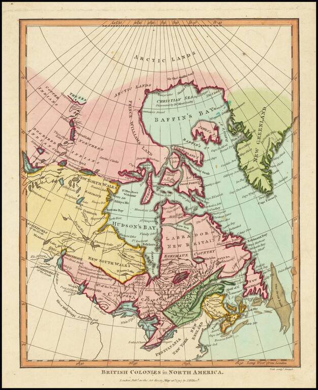
Includes a Reference to New Denmark.
This map purports to show the extent of British colonial power in North America, which at present was limited to eastern Canada. The map extends from "New Greenland" to the upper Mississippi. Curious details and notes abound on the map, especially in the poorly charted western regions. This map was published by John Wilkes, a British printer who lived from 1750-1810
On the map, the source of the Mississippi River is shown as a Lake Bourbon. Tributaries of the river very nearly reach other rivers that flow into Hudson's Bay. An uncertainly drawn New Sea cuts through Labrador, it is unclear what this is meant to represent. Baffin's Bay closed, and "Prince Williams Land" extends far to the north. The Coppermine River, as mapped by Samuel Hearne in 1771, flows into "The Sea."
Canada is divided into six provinces on the map. Quebec only extends along the banks of the St. Lawrence river, wrapped around by "Labrador or New Britain." Manitoba and Nunavut are labeled as "New South Wales" and "New North Wales."
Near Buttons Bay on Lake Hudson appears the name New Denmark. This refers to a failed colonization attempt of the western Hudson Bay by the Danish explorer Jens Munk. Munk arrived in the bay in 1619 alongside sixty-five men and settled for the winter near the presently known Churchill River. Only three men, including Munk, would survive the spring return to Bergen. All of Munk's later journeys to reestablish the colony would be thwarted, and a permanent Danish colony was never founded in the region.
Rarity
We locate only one separate institutional copy of this map in the McGill Pugsley collection.
If you are a student, write to us in telegram: @antiquemaps and indicate what material you need and for what work you need a map in high detail. We are ready to provide material on special terms. For students only!
![[The First Maps in a la poupée Printed Color] Cartes en Couleur des Lieux Sujets aux tremblements de Terre Dans toutes les parties du Monde Selon le Sisteme de l’impulsion Solaire](/map/small/52293op.jpg)

