Map size in jpg-format: 790957B
A Map with Flaps -- Beaurain's Progress Map of the Battle of Altenheim.
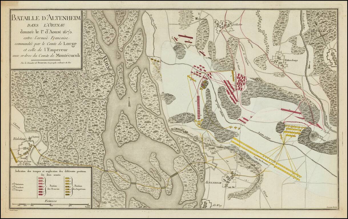
Fascinating depiction of the Battle of Altenheim (Konzer Brücke), by Beaurain, the Royal Geographer.
This is one of Beaurain's celebrated "map with flaps." This map of Altenheim, on the eastern side of the Rhine, has the lettering by Besançon, and overall engraving done by Berlin. It was one of several compiled Par le Chevalier de Beaurain. Géographe ordinaire du Roi for his self-published Histoire des quatre dernières campagnes du Maréchal de Turenne en 1672 [-] 1675 enrichie de cartes et plans topographiques (Paris, 1782).
An interesting feature of Beaurain's map is his use of paste-downs - or flaps. Three overlapping flaps on light blue paper demonstrate the different positions of the French and Imperial armies. An illustrated article on this feature is ' Maps with flaps: maps with printed overlays' in MapForum, Summer 2005, issue 6, pp.44-7.
Jean de Beaurain (1696-1771), was a French Geographer and Royal Geographer to King Louis XV.
About The Battle
The Battle of Konzer Brücke was fought as part of the Franco-Dutch War on August 11, 1675 and resulted in an Imperial victory.
In 1675 Montecuccoli and Turenne had been moving between Philippsburg and Strassburg for an advantage, each seeking to cover his own country and to live upon that of the enemy. At last Turenne prevailed and had the Imperialists at a disadvantage on the Sasbach, where, in opening the action, he was killed by a cannon-shot (27 July).
Devastated by the loss of their commander, the French hastily surrendered all their advantages, and Montecucculi sharply following up their retreat, and drove them over the Rhine and almost to the Vosges.
At the same time the Imperial forces under Charles IV, Duke of Lorraine were besieging Trier, which Turenne had taken in the autumn of 1673.
Créquy was sent with 15,000 men and 11 guns to relieve the city. They were stopped at the bridge over the Saar River at Konz.
The Imperialists sent a force under Ottone Enrico Del Carretto, marquis of Grana, to occupy what is today known as the Grana-heights. Another force crossed the bridge at Konz and a third force crossed the river over a pontoon bridge. They attacked the French camp and an indecisive battle raged for three hours. Then Otto de Grana engaged his right flank on the right moment and the French fled the battlefield, leaving behind all their guns and wagons. The Germans pursued the French.
Créquy made his way into Trier to assume command, but was forced to surrender on September 9, 1675.
If you are a student, write to us in telegram: @antiquemaps and indicate what material you need and for what work you need a map in high detail. We are ready to provide material on special terms. For students only!


