Map size in jpg-format: 19.8722MiB
Click to open in high resolution (open in new tab).
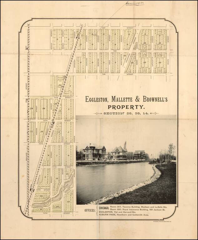
Rare early subdivision map of the Auburn Park area.
Auburn Park
Auburn Park is part of the area once known as Cummorn, most of which was owned by William B. Ogden, Chicago's first mayor and early real estate promoter.
The first railroad line through the area was constructed in 1852, and by the early 1870s, three other railroads ran through the community. Railroad workers began building homes in the area, and in 1872, Auburn platted.
The area was purchased in the 1870s by Eggleston, Mallette, and Brownell real estate speculators, who subdivided, drained, and began developing the land. Within several years, a second group of real estate developers, Sanford McKnight, Henry Mather and Alfred Manning, purchased the property. Sometime between the 1870s and 1890s, one of the two groups of developers created Auburn Park, an 8-acre landscape with a meandering lagoon, a remnant of the site's original wetlands.
In 1889, the Auburn community was annexed with Chicago. The following year, the city began maintaining the park, although it was still privately owned. Local residents wanted the site to become a public park. Between 1911 and 1913, the Auburn Park Improvement Association acquired and transferred the park to the city. The deed included covenants requiring that the land will forever be used as a park; the park and lagoon will always be maintained; and the name Auburn Park will never be changed. Considered the "beauty spot of Auburn," the park has long provided a calm refuge from the "weary" city.
If you are a student, write to us in telegram: @antiquemaps and indicate what material you need and for what work you need a map in high detail. We are ready to provide material on special terms. For students only!