Map size in jpg-format: 193.015MiB
Click to open in high resolution (open in new tab).
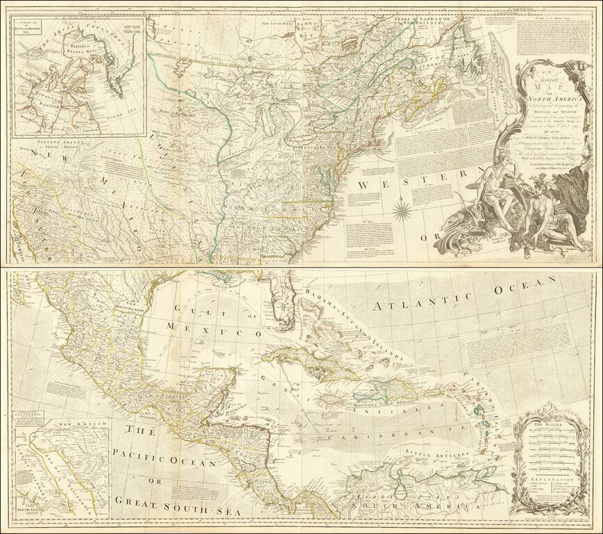
Striking 4-sheet map of North America on the eve of the American Revolution.
The map is one of the best large format representations of the British Colonies, from a British perspective, on the eve of the Revolution. The claims of the Carolinas, Virginia and Pennsylvania extend to the Mississippi, following the defeat of the French and the Treaty of Paris in 1763. A massive Louisiana appears West of the Mississippi, and Spain dominates Texas and Upper California. A large inset shows a full size reproduction of the seminal Kino map, which proved California not to be an island. There is also a large inset of Baffin's and Hudson's Bay. The elaborate cartouche is without doubt one of the most decorative cartouches to appear on an 18th Century map of America.
The extensive annotations in the Atlantic Ocean set forth the various articles of the Paris Treaty, which settled the French & Indian War--which Seymour Schwartz notes to be the bloodiest conflict on American soil during the 18th Century.
Includes a large inset of Baffin's and Hudson's Bay. The elaborate cartouche is without doubt one of the most decorative cartouches to appear on an 18th Century map of North America. The extensive annotations in the Atlantic Ocean set forth the various articles of the Paris Treaty, which settled the French & Indian War--which Seymour Schwartz notes to be the bloodiest conflict on American soil during the 18th Century.
Excellent detail throughout the map, including Indian Tribes, towns, forts, rivers, villages, mountains, lakes, trading places, portages, and a host of other important early colonial information.
Map States
This is the fourth state of the map, pre-dated only by the rare separately issued editions by Bowen & Gibson in 1755 and 1763 and Robert Sayer in 1772, which rarely appear on the market.
The 4 sheets are joined in two larger sheets, as issued. We will join the 2 sheets to form 1 large map, if requested.
If you are a student, write to us in telegram: @antiquemaps and indicate what material you need and for what work you need a map in high detail. We are ready to provide material on special terms. For students only!

![[Signed Political Satire Artwork] Vietnam ... Vietnam ... Vietnam ...](/map/small/68726.jpg)
