Map size in jpg-format: 42.3397MiB
Click to open in high resolution (open in new tab).
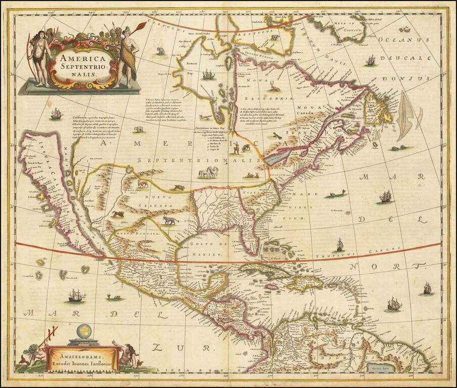
Hondius and Jansson’s Map of North America, A Map Central to the Myth of California as an Island
Striking example of the first state of Henricus Hondius’ and Jan Jansson’s map of North America, called by Burden the single most influential map in perpetuating the myth of California as an island to that date. It is also the first atlas map to focus exclusively on North America.
Although California is a prominent feature, it certainly is not the only interesting aspect of this map. A Rio del Norto flows from a large lake in the interior. In South America, another lake, Parime lacus is also shown, a reference to the El Dorado myth. On the eastern seaboard of North America, one can spot Iames Towne, the still small English settlement.
The map is a well-researched amalgam of the best cartographic resources available at the time. It first debuted in 1636; this is a second state with the signature of Joannes Janssonius [Jan Jansson] included in the lower left cartouche. For the western area, the Hondius house mapmakers drew upon Henry Briggs’ The North Part of AMERICA (1625). For the Gulf of Mexico and Florida, there are many similarities to Hessel Gerrtisz’s ca. 1631 chart. Some of the place names from John Smith’s map of Virginia are included, but the east coast north of Florida seems to be largely an original composition. The Gulf of St. Lawrence follows the work of De Laet and, to the north, the recent work by Thomas James (1633) is borrowed for the west coast of Hudson’s Bay.
In addition to the latest depiction of geographic features, the map features many decorative elements. Animals, including a polar bear, a fox, a boar, bison, and others roam the open North American interior. Ships and sea monsters dot the waters, including north of the island of California—a sly reference to the possible geography of that unmarked coast. The northwest coast is further obscured by a large title cartouche showing indigenous Americans in full battle dress flanking an ornate frame topped with various reptiles. In the lower left is another cartouche, this one with swimming putti using navigational equipment and staring at a globe. This second cartouche also contains Jansson’s name in this, the second state of the map.
California as an Island
From its first portrayal on a printed map by Diego Gutiérrez, in 1562, California was shown as part of North America by mapmakers, including Gerardus Mercator and Ortelius. In the 1620s, however, it began to appear as an island in several sources.
This was most likely the result of a reading of the travel account of Sebastian Vizcaino, who had been sent north up the shore of California in 1602. A Carmelite friar who accompanied him later described the land as an island, a description first published in Juan Torquemada’s Monarquia Indiana (1613) with the island details curtailed somewhat. The friar, Fray Antonio de la Ascension, also wrote a Relacion breve of his geographic ideas around 1620. The ideas spread about New Spain and, eventually, most likely via Dutch mariners and perhaps thanks to stolen charts, to the rest of Europe. By the 1620s, many mapmakers chose to depict the peninsula as an island.
No map was as important in the adoption of California as an island as this one. As the first atlas map to focus primarily on North America, it was the most widely distributed California as an island map of its time. California as it is shown here was based on the Briggs map, which was part of Samuel Purchas’ Hakluytus Posthumus or Purchas his Pilgrimes (1625). Amsterdam was then the center of the atlas trade, so this map enjoyed the widest circulation possible.
Other prominent practitioners like John Speed and Nicolas Sanson also adopted the new island and the practice became commonplace. Even after Father Eusebio Kino published a map based on his travels refuting the claim (Paris, 1705), the island remained a fixture until the mid-eighteenth century.
States and publication
The first was made in 1636 by Henricus Hondius; it is distinguished from this because the cartouche in the bottom left is blank as opposed to containing the name of Jan Jansson.
The second state appeared in 1641, adding Jansson's name to the blank cartouche at the bottom left.
The third state was a reissue by Petrus Schenk; it bears his imprint and has dotted lines demarcating regions.
The map was issued as part of the Atlas Novus, Hondius and Jansson’s highly successful atlas. This is an essential map for collectors of North America and California.
If you are a student, write to us in telegram: @antiquemaps and indicate what material you need and for what work you need a map in high detail. We are ready to provide material on special terms. For students only!


![[Signed Political Satire Artwork] Vietnam ... Vietnam ... Vietnam ...](/map/small/68726.jpg)