logo

1794. America North and South and the West Indies; with the Atlantic, Aetheopic and Pacific; wherein are Distinguished, All the Discoveries lately made by the English and the Spaniards . . . 1794

  • America North and South and the West Indies; with the Atlantic, Aetheopic and Pacific;  wherein are Distinguished, All the Discoveries lately made by the English and the Spaniards . . . 1794

America North and South and the West Indies; with the Atlantic, Aetheopic and Pacific; wherein are Distinguished, All the Discoveries lately made by the English and the Spaniards . . . 1794 information:

Year of creation: 
Resolution size (pixels): 
 12137x8867 px
Disk Size: 
 23.0902MiB
Number of pages: 
 1
Place: 
 London

Print information. Print size (Width x height in inches):
Printing at 72 dpi 
  168.57 х 123.15
Printing at 150 dpi 
 80.91 х 59.11
Printing at 300 dpi 
 40.46 х 29.56

An example of detailing the file of this map of in a printable high-resolution:

Click to open in high resolution (open in new tab).
Attention! this is just the central piece (central area 960x960 px) of the map file!
This is an example, so that you can see and study the level of detail of a given map. The entire Map will be fully available after payment!

America North and South and the West Indies; with the Atlantic, Aetheopic and Pacific;  wherein are Distinguished, All the Discoveries lately made by the English and the Spaniards . . . 1794

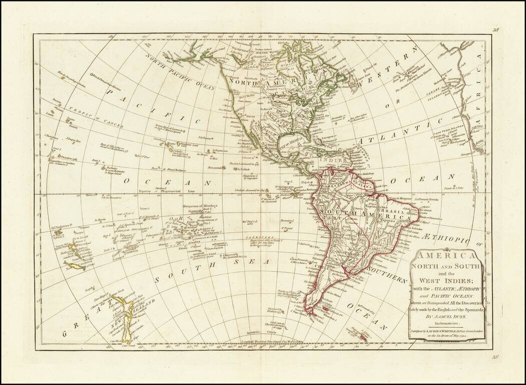
Interesting map of America, published shortly after the dissemination of the Official Account of Captain James Cook's Third Voyage.

The map retains the location of Mendana's Land west of Hawaii, a reference to a pre-Cook Spanish expedition that may have touched on Hawaii in the 16th Century, but for which the details remain debated among scholars.

On the northwest Coast of America, the River of the West, extending from Lake Winnipeg to the Pacific is shown, as is the "Tortolas River," extending from Woods Lake (Lake of the Woods) to the California Coastline, with no sign of the Rocky Mountains given.

In the Arctic Regions, no defined coastline is shown west of Hudson's Bay.

James Whittle (1757-1818) was a British engraver and map printer. Whittle was employed by Robert Sayer (ca. 1725-1794). Together with Robert Laurie (1755?-1836), he took on Sayer’s business when the older man died in 1794. The two traded together as Laurie & Whittle until 1812, when Laurie retired. They had specialized in sea charts and maritime atlases. Whittle then partnered with Laurie’s son, Richard Holmes Laurie, until he died in 1818.


Special conditions for students!

If you are a student, write to us in telegram: @antiquemaps and indicate what material you need and for what work you need a map in high detail. We are ready to provide material on special terms. For students only!

Item information:

Year of creation:
Size:
12137x8867 px
Disk:
23.0902MiB
Number of pages:
1
Place:
London
Author:
James Whittle. Robert Laurie.
$14.99

Related item