logo

1817. Allgemeine Weltkarte der Regierungsformen vom Jahr 1817 . . .

  • Allgemeine Weltkarte der Regierungsformen vom Jahr 1817 . . .

Allgemeine Weltkarte der Regierungsformen vom Jahr 1817 . . . information:

Year of creation: 
Resolution size (pixels): 
 11598x8383 px
Disk Size: 
 22.0512MiB
Number of pages: 
 1
Place: 
 Weimar

Print information. Print size (Width x height in inches):
Printing at 72 dpi 
  161.08 х 116.43
Printing at 150 dpi 
 77.32 х 55.89
Printing at 300 dpi 
 38.66 х 27.94

An example of detailing the file of this map of in a printable high-resolution:

Click to open in high resolution (open in new tab).
Attention! this is just the central piece (central area 960x960 px) of the map file!
This is an example, so that you can see and study the level of detail of a given map. The entire Map will be fully available after payment!

Allgemeine Weltkarte der Regierungsformen vom Jahr 1817 . . .

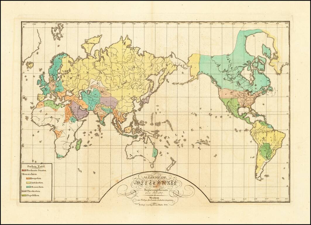
A World Map of Despots, Theocrats, Monarchs and Autocrats, etc.

Rare map of the world, illustrating the the different governments of the world in 1817.

The key locates 6 typles of Government:

  • Federated States
  • Monarchies - Despots
  • Monarchies - Autocrats
  • Monarchies
  • Theocrats
  • Republics

The map was apparently issued as a supplement to Oppositions Blatt, No. 1, published in Weimar.

Rarity

The map is extremely rare. We locate only the example in the Austrian State Archives.


Special conditions for students!

If you are a student, write to us in telegram: @antiquemaps and indicate what material you need and for what work you need a map in high detail. We are ready to provide material on special terms. For students only!

Item information:

Year of creation:
Size:
11598x8383 px
Disk:
22.0512MiB
Number of pages:
1
Place:
Weimar
Author:
Weimar Geographische Institut.
$14.99

Related item