Map size in jpg-format: 1.39407MiB
Click to open in high resolution (open in new tab).

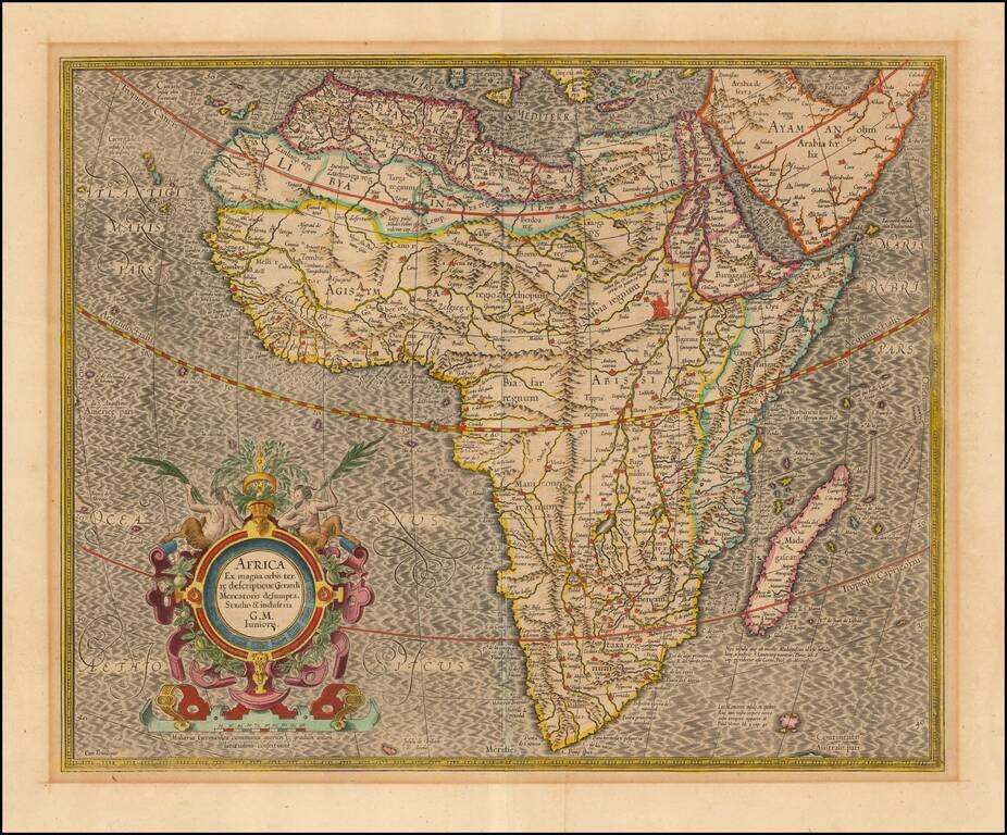
Nice old color example of the most influential maps of Africa published at the end of the 16th century.
Mercator's finely engraved map of Africa depicts the continent as it was known in the late 16th century. This map is based on Gerard Mercator's twenty-one sheet wall map of the World, first published in 1569. The atlas version of the map was engraved by the first Gerard Mercator's grandson Gerard, in 1595, the year after Gerard Mercator's death. This map has a high degree of accuracy especially along the coastline that was unsurpassed by any other 16th century cartographer. Much of the interior of Africa defers to the traditions of Ptolemy; the Nile river is shown with two lakes and the Mountains of the Moon across southern Africa. Mercator does show European advance into the interior. For example, Mercator shows Portuguese exploration up the Cuama (Zambezi) River into the interior of south central Africa in the region of Monomotapa or Benamataxa, as he named it on his map. Ca. Portogal (the Portuguese Fort) is placed on the map within the junction of the Spirito and Cuama rivers.
Mercator tried to adhere to a more scientific approach and did not include the numerous beasts of other cartographers. The only figure within Africa is the seated legendary priest-king Prester John in Ethiopia. The cartouche is quite decorative with fruit and two satyrs. The fine script is superb and the sea has Mercator's signature moiré pattern.
If you are a student, write to us in telegram: @antiquemaps and indicate what material you need and for what work you need a map in high detail. We are ready to provide material on special terms. For students only!
![[Eastern Hemisphere Globe Gores] (Nova et integra universi Orbis descriptio)](/map/small/54480.jpg)