Map size in jpg-format: 51.9997MiB
Click to open in high resolution (open in new tab).
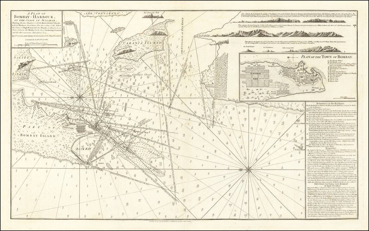
The First Modern Chart of Mumbai (Bombay) Harbor
Fine example of the second edition of William Nichelson's charting of Bombay Harbor, published in 1794 by Laurie & Whittle. The second edition notes that it is "Correct by Capt. Watson".
The map covers from Salsette Island to the continent south to Hunary Island. There is a detailed plan of the city of Bombay as well as several coastal profile views in the upper right quadrant. This is arguably the largest and finest obtainable nautical chart of Bombay Harbor to appear in the 18th century. The map offers rich detail including countless depth soundings, notes on the sea floor, commentary on reefs, rhumb lines, shoals, place names and a wealth of other practical information for the mariner. Though most charts in the East-India Pilot were derived from earlier maps prepared for Jean-Baptiste d'Apres de Mannevillette's 1745 Neptune Oriental, this particular chart is a new and uniquely British production.
Cartographically, the map is derived from surveys by Captain William Nichelson and Captain Watson. Nichelson, master of the HMS Elizabeth, made a survey of Bombay Harbor and coast of Malabar in 1763, creating a monumental 8 sheet of the Harbor in 1763.
The original map is known in a single example, of which only 7 of the 8 sheets have survived. In about 1780, William Herbert produced a chart entitled A Reduced Chart of Bombay Harbour to serve as an Index for the large one of eight sheets by Wm. Nichelson, Master of the H.M.S. Elizabeth.
This chart represents a massive leap forward in the charting of the Bay, significantly improving upon prior charts by Van Keulen and Mannevillette, as well as Samuel Thornton's Chart of Bombay.
Rarity
The map is quite scarce on the market, this being the first example we have offered for sale.
Laurie & Whittle refers to the partnership of Robert Laurie (1755?-1836) and James Whittle (1757-1818), engravers and map publishers. Both men were employed by Robert Sayer (ca. 1724-1794), one of the most prominent British publishers and map sellers of the eighteenth century. Sayer died in 1794 and his business was taken over by his assistants. The two worked together as Laurie & Whittle until 1812, when Laurie retired. They were especially known for publishing sea charts and maritime atlases. From 1812-1818, when he died, Whittle worked with Laurie’s son, Richard Holmes Laurie, as Whittle & Laurie. After 1818, the firm was known as R. H. Laurie, even though Richard died in 1858. Later, the firm was managed by Laurie’s draughtsman, Alexander George Findlay, and, later, Daniel and William Kettle.
If you are a student, write to us in telegram: @antiquemaps and indicate what material you need and for what work you need a map in high detail. We are ready to provide material on special terms. For students only!

![Il Disegno Della Terza Parte Dell' Asia [Gastaldi's Wall Map of SE Asia with extra panels!]](/map/small/30554hbp.jpg)
