Map size in jpg-format: 2.45082MiB
Click to open in high resolution (open in new tab).
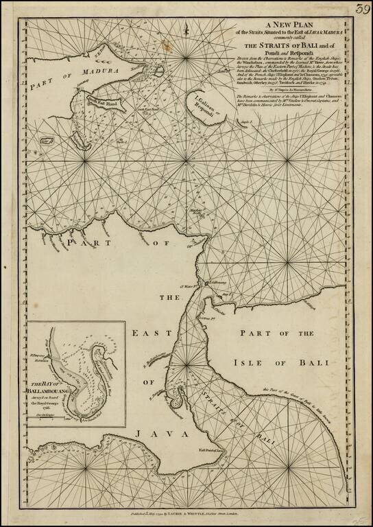
Scarce sea chart of the Straits of Bali and part of Madura, with a large inset of the Bay of Ballambouang, showing the narrow channel between the Isand of Bali and East Java.
Includes extensive details and soundings. The northeastern part of Borneo is also shown. The focus of the map is on the coastal features, but there is also detail along several of the major rivers.
Laurie & Whittle refers to the partnership of Robert Laurie (1755?-1836) and James Whittle (1757-1818), engravers and map publishers. Both men were employed by Robert Sayer (ca. 1724-1794), one of the most prominent British publishers and map sellers of the eighteenth century. Sayer died in 1794 and his business was taken over by his assistants. The two worked together as Laurie & Whittle until 1812, when Laurie retired. They were especially known for publishing sea charts and maritime atlases. From 1812-1818, when he died, Whittle worked with Laurie’s son, Richard Holmes Laurie, as Whittle & Laurie. After 1818, the firm was known as R. H. Laurie, even though Richard died in 1858. Later, the firm was managed by Laurie’s draughtsman, Alexander George Findlay, and, later, Daniel and William Kettle.
If you are a student, write to us in telegram: @antiquemaps and indicate what material you need and for what work you need a map in high detail. We are ready to provide material on special terms. For students only!
![[Signed Political Satire Artwork] Vietnam ... Vietnam ... Vietnam ...](/map/small/68726.jpg)
![[Martin Behaim Globe / Book] Pars Globi terrestris Ao. 1492 a Martino Behaim Equite Lusitano Norimbergae confecti Delineavit Christoph. Theoph de Murr 1778 (bound with:) Diplomatische Geschichte des Portugesischen berühmten Ritters Martin Behaims](/map/small/68828.jpg)
![Il Disegno Della Terza Parte Dell' Asia [Gastaldi's Wall Map of SE Asia with extra panels!]](/map/small/30554hbp.jpg)