Map size in jpg-format: 75.9314MiB
Click to open in high resolution (open in new tab).
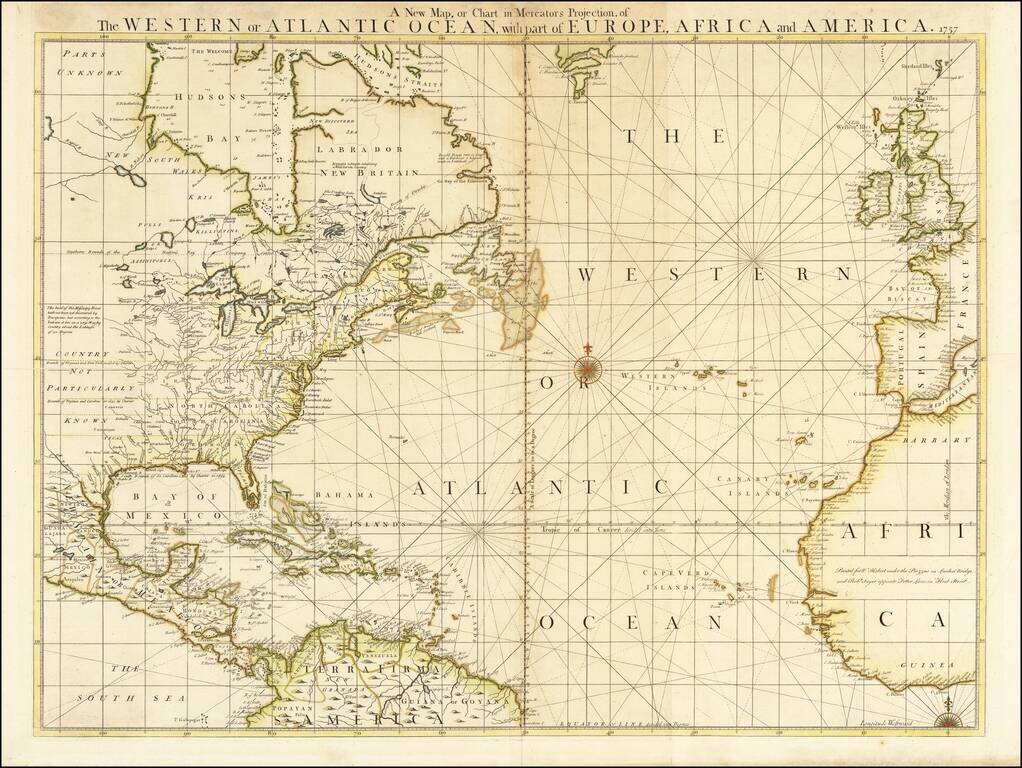
Rare Map of the Atlantic at the Outset of the French & Indian War
Extremely rare separately issued map of North America, The Caribbean and the Atlantic Ocean, issued by William Herbert in London.
The map is richly annotated with information both within North America an in the Atlantic, including notes on La Salle's explorations and the headwaters of the Mississippi (undiscovered by European Explorers but known to extend to a marshy region at 50 degrees latitude according to Indian Sources).
There are many forts, both English and French, as well as Fort St. John on the Rio Bravo. There are also some fascinating notes in the Atlantic regarding the location of little known (mythical?) islands and other details.
Rarity
The map is extremely rare.
There is no record of the map appearing on the market in the past 25 years and this example of the Herbert is the first to appear since offered by Jonathan Potter in 1997. This is the same example that we previously offered and sold in 2009.
Robert Sayer (ca. 1724-1794) was a prominent London map publisher. Robert’s father was a lawyer, but his older brother married Mary Overton, the widow of prominent mapmaker Philip Overton and the proprietor of his shop after his death. Mary continued the business for roughly a year after her marriage and then, in early 1748, it passed to Robert. Robert became a freeman of the Stationers’ Company later that year; his first advertisement as an independent publisher was released in December.
Sayer benefited from Overton’s considerable stock, which included the plates of John Senex. In the 1750s, Sayer specialized in design books and topographical prints, as well as comic mezzotints. In 1753, he, along with John Roque, published a new edition of Thomas Read’s Small British Atlas, the first of several county atlases that Sayer would publish.
Sayer’s business continued to grow. In 1760 he moved further down Fleet Street to larger premises at 53 Fleet Street. In 1766, he acquired Thomas Jefferys’ stock when the latter went bankrupt. In 1774, he entered into a partnership with John Bennett, his former apprentice. The pair specialized in American atlases, based on the work of Jefferys. They also began publishing navigational charts in the 1780s and quickly became the largest supplier of British charts in the trade.
Bennett’s mental health declined, and the partnership ended in 1784. As Sayer aged, he relied on his employees Robert Laurie and James Whittle, who eventually succeeded him. He spent more and more time at his house in Richmond. In 1794, he died in Bath.
If you are a student, write to us in telegram: @antiquemaps and indicate what material you need and for what work you need a map in high detail. We are ready to provide material on special terms. For students only!


