logo

1750. A Map of the British Empire in America, from the Head of Hudson Bay to the Southern Bounds of Georgia, with the intervention of Canada

  • A Map of the British Empire in America, from the Head of Hudson Bay to the Southern Bounds of Georgia, with the intervention of Canada

A Map of the British Empire in America, from the Head of Hudson Bay to the Southern Bounds of Georgia, with the intervention of Canada information:

Year of creation: 
Resolution size (pixels): 
 7515x6307 px
Disk Size: 
 11.3414MiB
Number of pages: 
 1
Place: 
 London

Print information. Print size (Width x height in inches):
Printing at 72 dpi 
  104.38 х 87.6
Printing at 150 dpi 
 50.1 х 42.05
Printing at 300 dpi 
 25.05 х 21.02

An example of detailing the file of this map of in a printable high-resolution:

Click to open in high resolution (open in new tab).
Attention! this is just the central piece (central area 960x960 px) of the map file!
This is an example, so that you can see and study the level of detail of a given map. The entire Map will be fully available after payment!

A Map of the British Empire in America, from the Head of Hudson Bay to the Southern Bounds of Georgia, with the intervention of Canada

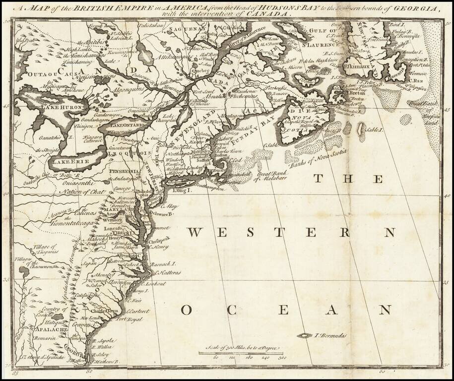
Very rare pre-Mitchell map of the British Colonies in Noth America, published pursuant to Act of Parliament in November 1750, for Owen's Magazine of Magazines.

The map shows the northeast from Newfoundland to Georgia and west to just beyond Lake Erie, Lake Huron and Hitanachi or St. Esperit River (an early name for the Apalachiola River).

Of perhaps greatest note is the lack of reference to any French Forts west of the Alleghany mountains in the Ohio Valley, as this had not yet become a major subject of contention.

The configuration of the Del-Mar-Va peninsula is very unusual. The boundary line for Pennsylvania does not include Delaware (given to Maryland) and extends only just past the Susquehanna with a mysterious lake to the west. Numerous Indian tribes are named and a couple more mystery lakes shown in the south.

(McCorkle #750.3); Jolly, D.C. (Brit Per) MOM-2.

Special conditions for students!

If you are a student, write to us in telegram: @antiquemaps and indicate what material you need and for what work you need a map in high detail. We are ready to provide material on special terms. For students only!

Item information:

Year of creation:
Size:
7515x6307 px
Disk:
11.3414MiB
Number of pages:
1
Place:
London
Author:
Owen's Magazine of Magazines.
$14.99

Related item