Map size in jpg-format: 156.322MiB
Click to open in high resolution (open in new tab).
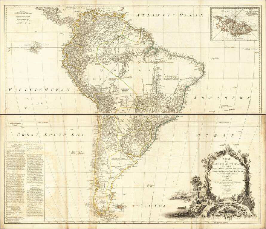
Detailed 4-sheet map of South America, based upon and earlier French map by D'Anville.
Includes a large inset map of the Falklands. South America is shown during the Bourbon Englightenment period, when Spain was finally beginning to share more information regarding the interior details of their valuable colonies in North America, several decades prior to the first of the South American Revolutions which would reshape the continent in the first part of the 19th Century.
The map attempts to show the details of the Amazon and its major tributaries, although several of the major southern tributary rivers, most notably the Rio Paranatinga ("which falls in the Amazon as the Rio Zingu"), Rio Purus and the Rio Yutay are largely conjecture.
The Uruguayan-Brazilian Tape area is virtually unknown, with a lengthy note:
Most of this Inland is unknown The Natives bear the general Name of Tapayos they are composed of many Nations, differ in Manners and Language, tho Guarauni Tongue extends itself among these People, as well as the other Natives of Brasil.
To the South the Pampas and Patagonian regions are similarly devoid of meaningful detail in the interior and still nearly completely unknown and unsettled.
Robert Sayer (ca. 1724-1794) was a prominent London map publisher. Robert’s father was a lawyer, but his older brother married Mary Overton, the widow of prominent mapmaker Philip Overton and the proprietor of his shop after his death. Mary continued the business for roughly a year after her marriage and then, in early 1748, it passed to Robert. Robert became a freeman of the Stationers’ Company later that year; his first advertisement as an independent publisher was released in December.
Sayer benefited from Overton’s considerable stock, which included the plates of John Senex. In the 1750s, Sayer specialized in design books and topographical prints, as well as comic mezzotints. In 1753, he, along with John Roque, published a new edition of Thomas Read’s Small British Atlas, the first of several county atlases that Sayer would publish.
Sayer’s business continued to grow. In 1760 he moved further down Fleet Street to larger premises at 53 Fleet Street. In 1766, he acquired Thomas Jefferys’ stock when the latter went bankrupt. In 1774, he entered into a partnership with John Bennett, his former apprentice. The pair specialized in American atlases, based on the work of Jefferys. They also began publishing navigational charts in the 1780s and quickly became the largest supplier of British charts in the trade.
Bennett’s mental health declined, and the partnership ended in 1784. As Sayer aged, he relied on his employees Robert Laurie and James Whittle, who eventually succeeded him. He spent more and more time at his house in Richmond. In 1794, he died in Bath.
If you are a student, write to us in telegram: @antiquemaps and indicate what material you need and for what work you need a map in high detail. We are ready to provide material on special terms. For students only!


![[Signed Political Satire Artwork] Vietnam ... Vietnam ... Vietnam ...](/map/small/68726.jpg)