logo

1940. A Hysterical Map Of Grand Coulee Dam -- All Connected Up With Running Water -- Added Attraction -- Dry Falls

  • A Hysterical Map Of Grand Coulee Dam -- All Connected Up With Running Water -- Added Attraction -- Dry Falls

A Hysterical Map Of Grand Coulee Dam -- All Connected Up With Running Water -- Added Attraction -- Dry Falls information:

Year of creation: 
Resolution size (pixels): 
 9675x9695 px
Disk Size: 
 27.2058MiB
Number of pages: 
 1
Place: 
 Spokane, WA
Author: 

Print information. Print size (Width x height in inches):
Printing at 72 dpi 
  134.38 х 134.65
Printing at 150 dpi 
 64.5 х 64.63
Printing at 300 dpi 
 32.25 х 32.32

An example of detailing the file of this map of in a printable high-resolution:

Click to open in high resolution (open in new tab).
Attention! this is just the central piece (central area 960x960 px) of the map file!
This is an example, so that you can see and study the level of detail of a given map. The entire Map will be fully available after payment!

A Hysterical Map Of Grand Coulee Dam -- All Connected Up With Running Water -- Added Attraction -- Dry Falls

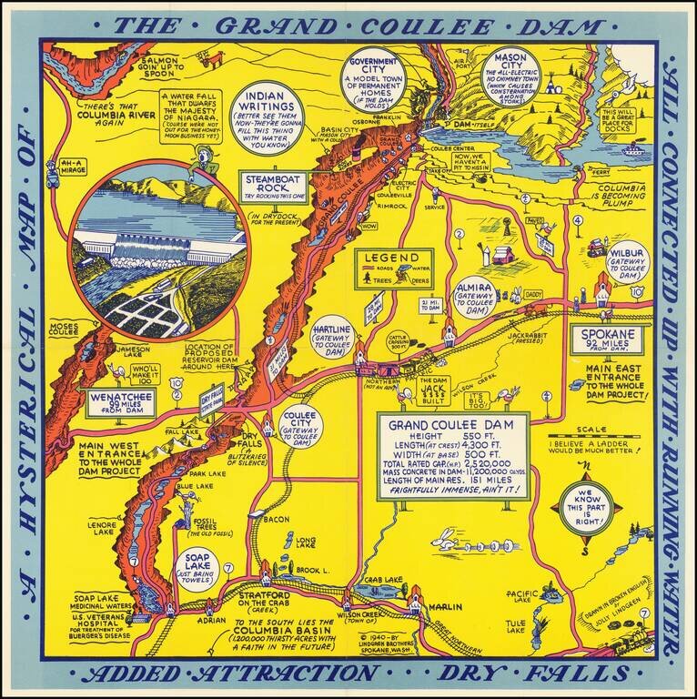
Second of two whimsical maps of Grand Coulee Dam, published by the Lindgren Brothers, "Drawn In Broken English by Jolly Lindgren," this comic pictorial map is full of puns and comic vignettes related to Grand Coulee Dam.

The Lindgren Brothers issued a number of other silly whimsical maps of national parks and other parts of the West.

This example follows the 1935 edition, which does not include a title around the border.


Special conditions for students!

If you are a student, write to us in telegram: @antiquemaps and indicate what material you need and for what work you need a map in high detail. We are ready to provide material on special terms. For students only!

Item information:

Year of creation:
Size:
9675x9695 px
Disk:
27.2058MiB
Number of pages:
1
Place:
Spokane, WA
Author:
Lindgren Brothers.
$14.99

Related item