logo

1948. A Hysterical Map Of Death Valley National Monument -- And It's Looking Mighty Low

  • A Hysterical Map Of Death Valley National Monument -- And It's Looking Mighty Low

A Hysterical Map Of Death Valley National Monument -- And It's Looking Mighty Low information:

Year of creation: 
Resolution size (pixels): 
 10132x13078 px
Disk Size: 
 37.3115MiB
Number of pages: 
 1
Place: 
 Spokane, WA
Author: 

Print information. Print size (Width x height in inches):
Printing at 72 dpi 
  140.72 х 181.64
Printing at 150 dpi 
 67.55 х 87.19
Printing at 300 dpi 
 33.77 х 43.59

An example of detailing the file of this map of in a printable high-resolution:

Click to open in high resolution (open in new tab).
Attention! this is just the central piece (central area 960x960 px) of the map file!
This is an example, so that you can see and study the level of detail of a given map. The entire Map will be fully available after payment!

A Hysterical Map Of Death Valley National Monument -- And It's Looking Mighty Low

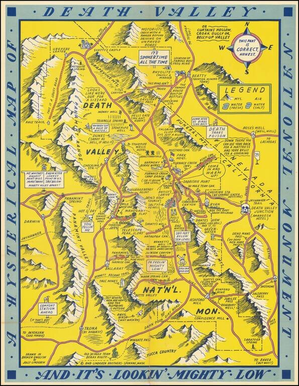
First edition of this humorous map of Death Valley. "Drawn In Broken English by Jolly Lindgren," this comic pictorial map is full of puns and comic vignettes related to Death Valley.

The Lindgren Brothers issued a number of other silly whimsical maps of national parks and other parts of the West.


Special conditions for students!

If you are a student, write to us in telegram: @antiquemaps and indicate what material you need and for what work you need a map in high detail. We are ready to provide material on special terms. For students only!

Item information:

Year of creation:
Size:
10132x13078 px
Disk:
37.3115MiB
Number of pages:
1
Place:
Spokane, WA
Author:
Lindgren Brothers.
$14.99

Related item