Philippe Buache (1700-1773) was one of the most famous French geographers of the eighteenth century. Buache was married to the daughter of the eminent Guillaume Delisle and worked with his father-in-law, carrying on the business after Guillaume died. Buache gained the title geographe du roi in 1729 and was elected to the Academie des Sciences in the same year. Buache was a pioneering theoretical geographer, especially as regards contour lines and watersheds. He is best known for his works such as Considérations géographiques et physiques sur les découvertes nouvelles dans la grande mer (Paris, 1754).
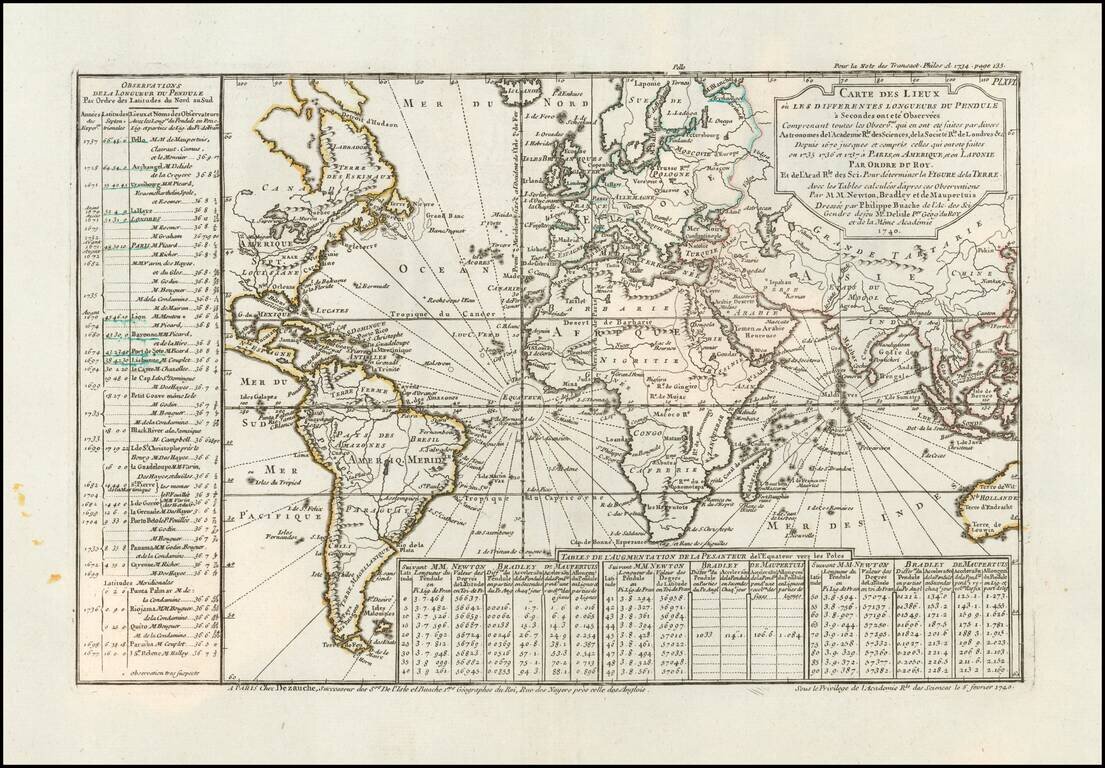
Comparing the Observations of Newton, Bradley and Maupetius Rare map centered on Europe, without the western part of North America or the Pacific. The map includes tables showing variations in longitude and latitude, as calculated by Newton, Bradley...
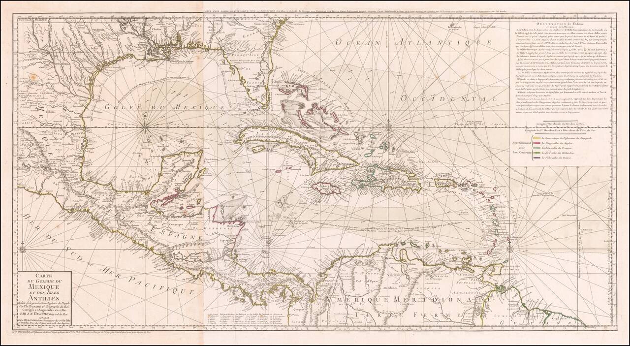
Striking, Intricate Map of the Caribbean Region Scarce and highly-detailed map of the Gulf Coast, Florida, Central America and the Caribbean from J.A. Dezauche, successor to Philippe Buache and Guillaume De L'Isle. The map is incredibly detailed, not...
![[A Coruña / Ferrol] Carte Hidro-Topographique des Entrees et Ports du Ferol et de la Corogne Publiee Par M.Degaulle . . . 1786](/map/small/54546.jpg)
Rare 18th Century harbor plan of the A Coruña Bay on the Galician Coastline of Spain. The map was prepared under the direction of the French Depot de la Marine, showing soundings, coastal features, towns, anchorages, the primary channel through A...
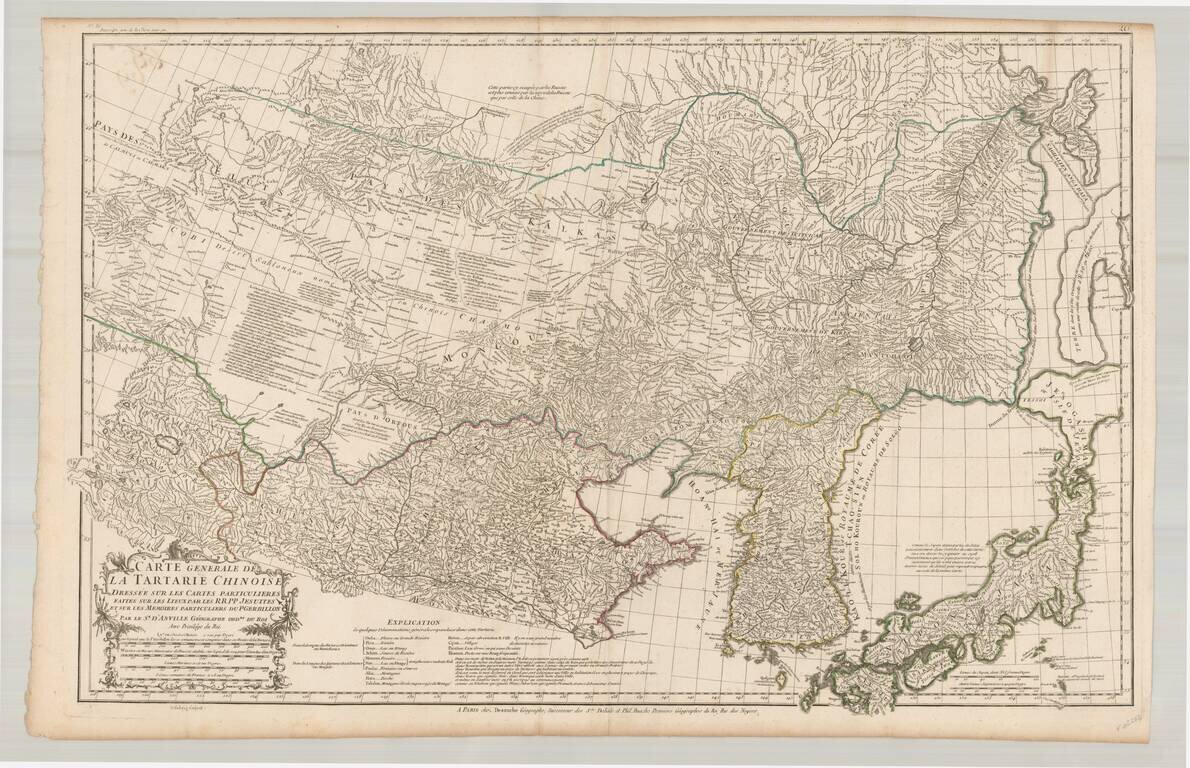
Fine example of the rare JA Dezauche edition of D'Anville's map of the region from Japan to the Gobi Desert, centered on Mongolia and Korea, from D'Anville's Atlas of China. Includes a nice treatment of Korea, Japan and China, along with a detailed...
![[Tibet] Carte Generale Du Tibet ou Bout-Tan Et Des Pays De Kashgar Et Hami Dressee Sur Les Cartes Et Memoires Des RR PP Jesuits De La Chine . . .](/map/small/43409.jpg)
Fine example of the Dezauche edition of the first European map of Tibet, first issued in 1737 by D'Anville. Much of the interior is captioned "Gobi ou Desert De Sable" (Gobi, or Sandy Desert) and several rivers are shown "lost" in the sands. There are...
![[Title Page] Atlas Geographique et Universel . . .](/map/small/64661.jpg)
Finely engraved allegorical title page, issued in a later edition of the De L'Isle-Buache-Dezauche Atlas Geographique.