Louis Claude Desaulses de Freycinet (1779-1841) was a French hydrographer and explorer. He joined the French Navy in 1793. In October 1800, at the age of 21, Freycinet set off in the Naturaliste, part of an exploratory expedition to chart Australia. He was accompanied on this voyage by his brother, Louis-Henri, who would go on to become an admiral.
In Sydney, the leader of the expedition, Nicholas Baudin, purchased a 29-foot vessel. He named it Casuarina and placed Freycinet, who had proven himself an adroit hydrographer, in command. With his new charge, Freycinet was to perform inshore surveys. During the course of 1802, the Casuarina charted large portion of the southern coast of Australia.
Freycinet returned to France in 1804. Since Baudin had died in Mauritius, the naturalist Francois Peron and Freycinet were directed to prepare for publication the official account of the voyage, with an accompanying atlas. The official account appeared over ten years and in four volumes. The first narrative of the voyage, primarily by Peron, was published in 1807. The second narrative volume was published in 1816 and was written primarily by Freycinet. Peron had died in 1810. The first part of the Atlas, which contained 40 engraved plates, two of them folding, appeared in 1807. The second atlas, was published in 1811 with 14 engraved charts, two of them double-page. These double-page maps include a map of the Australian continent, the first map to show the continent in its entirety and made partially from Matthew Flinders’ papers.
His publications stemming from the Baudin expedition would have been enough to secure the fame of Louis Freycinet. However, he is perhaps best known today for his second voyage to the Pacific, one he commanded in the Uranie. From 1817 to 1820, Freycinet cruised the Pacific performing experiments and, of course, making detailed charts. He was accompanied by his wife Rose.
Although the Uranie was wrecked in the Falklands on the return journey, the natural historical specimens and geographical notes were saved. They were published in 13 volumes with 4 additional volumes of plates and maps between 1824 and 1844.
The voyage secured Freycinet a place in the Academie des Sciences. He also went on to help found the Paris Geographical Society, the first such group of its kind. Louis Freycinet died in 1841.
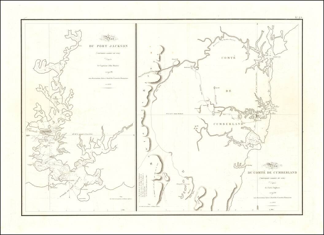
One of the Earliest Maps of Port Jackson - From the Expedition of Nicholas Baudin The two maps reflect one of the earliest scientific surveys of Port Jackson and the area around Sydney Harbor, undertaken by the French in 1802. During Nicolas Baudin's...
![[Western Australia] Carte de la Terre D'Edels et d'une partie De Celle D'Endracht (a la Nouvelle Hollande) Dressee Par M. L. Freycinet, Commandans la Goelette le Casuarina. (1801 & 1803) (Rare Separately Published Example)](/map/small/53267.jpg)
Rare Separately-Issued Chart of Western Australia from Freycinet's Surveys as Part of the Baudin Expedition Intricately detailed chart of the coastline of Western Australia, which until this time had only been sporadically encountered by Dutch ships...
![[Hunter Island / Tasmania] Carte des Iles Hunter dressee Par L. Freycinet, Commandant la Goelette le Casuarina, d'apres ses observations et celles de Mr. Boullanger Ingenieur Hydrographe -- December 1802. (Rare separately published example)](/map/small/53891.jpg)
Rare Separately Published Example of Freycinet's Rare and Separately Issued Chart of Hunter Island Striking separately published example of the Freycinet chart of Hunter Island, in the waters off Tasmania, or Van Diemen's Land. The chart is drawn...
![[]Hunter Island / Tasmania] Carte Trigonometrique des Iles Hunter dressee Par L. Freycinet, Commandant le Casuarina -- December 1802 (Rare Separately Published Example)](/map/small/53937.jpg)
Rare Separately-Issued Example of Freycinet's Trigonometric Survey of Hunter Island, off the Coast of Tasmania, the Earliest Detailed Charting of the Area Rare separately published example of this fine intricately detailed chart of the waters off...
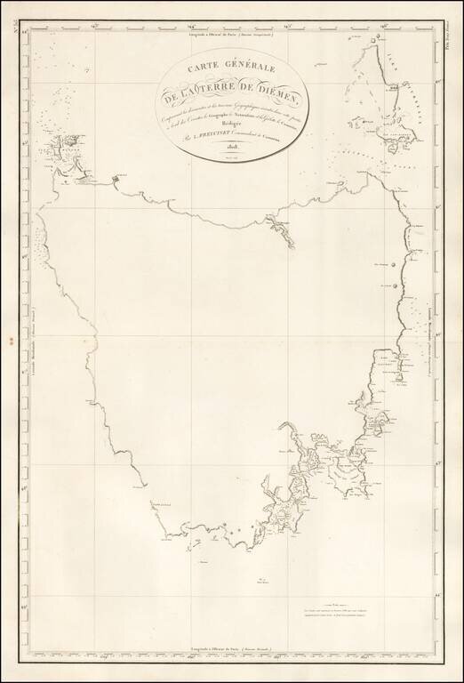
First Map of the Entire Island of Van Diemen's Land-Striking, Rare, Separately-Issued Chart of Tasmania from the Baudin Expedition Detailed chart of the island of Tasmania as surveyed during the Baudin expedition and published by expedition member...
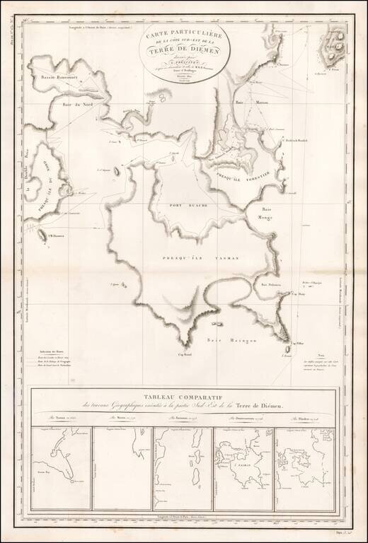
Rare, Detailed, Separately-Issued Chart of Southeast Van Diemen's Land from the Baudin Expedition Comprehensive chart of the southeast portion of the island of Tasmania as surveyed during the Baudin expedition and published by expedition member Louis...